Waterway information

Kind:
Inland
Driving areas:
🇳🇱 Netherlands
Length:
6.3 km¹
¹River kilometers or bank length recorded in NavShip, including river arms and harbor entrances.
Availability:
Completely recorded
Recent Update: 22.05.2023²
² This date indicates when an adjustment last took place in the course of the body of water
Recorded:
Locks: 0
Harbours / marinas: 2
Bridges: 6
Berths: 2
Slipways: 0
Fuelstations: 0
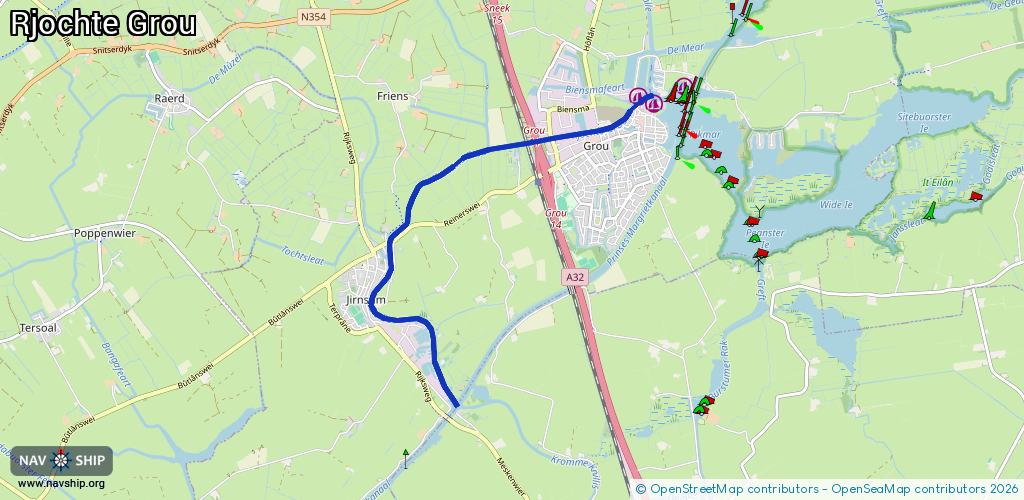
Route:
Please wait, loading route graphic...
Request waterway overview map with symbol legend here (Link).
Information about data associated with this body of water (10 available):
Data by OpenSeaMap (c) OSM contributors, www.openseamap.org
| # | Kind | Coordinates | Name | Information |
|---|---|---|---|---|
| 1 | Marina | 53.09864,5.83948 | 2023-09-18T08:44:23Z | De Oerhaal |
| 2 | Marina | 53.09791,5.84205 | 2025-06-12T05:19:54Z | Passantenhafen +31 6 53151298 https://www.grou.nl/haveninformatie |
| 3 | Bridge | 53.08371,5.79671 | 7.8 | Clearance height: 2024-09-12T13:36:49Z m Maximum passage width: 2.5 m Movable bridge (e.g. lifting bridge or drawbridge) fixed |
| 4 | Bridge | 53.09392,5.82028 | 7.1 | Clearance height: 2020-06-05T11:33:43Z m Maximum passage width: 1.9 m Movable bridge (e.g. lifting bridge or drawbridge) fixed |
| 5 | Bridge | 53.09412,5.82195 | 9.1 | Clearance height: 2024-10-06T16:16:55Z m Maximum passage width: 2 m fixed |
| 6 | Bridge | 53.09444,5.82455 | 9.4 | Clearance height: 2024-10-06T16:16:55Z m Maximum passage width: 2.6 m Movable bridge (e.g. lifting bridge or drawbridge) fixed |
| 7 | Bridge | 53.09529,5.83276 | 7.41 | Clearance height: 2024-10-05T17:57:48Z m Maximum passage width: 3.3 m opening Fietsbrug in de J.W. de Visserwei |
| 8 | Bridge | 53.0956,5.83693 | Unknown | Clearance height: 2024-10-05T09:44:17Z m opening |
| 9 | Berth | 53.06796,5.80767 | 2023-11-21T00:33:16Z | SN01 |
| 10 | Berth | 53.06704,5.80707 | 2018-12-07T21:22:10Z |