Waterway information

Kind:
Inland
Driving areas:
🇺🇸 United States of America
Length:
3.5 km¹
¹River kilometers or bank length recorded in NavShip, including river arms and harbor entrances.
Availability:
Completely recorded
Recent Update: 19.02.2024²
² This date indicates when an adjustment last took place in the course of the body of water
Recorded:
Locks: 0
Harbours / marinas: 13
Bridges: 0
Berths: 0
Slipways: 0
Fuelstations: 1
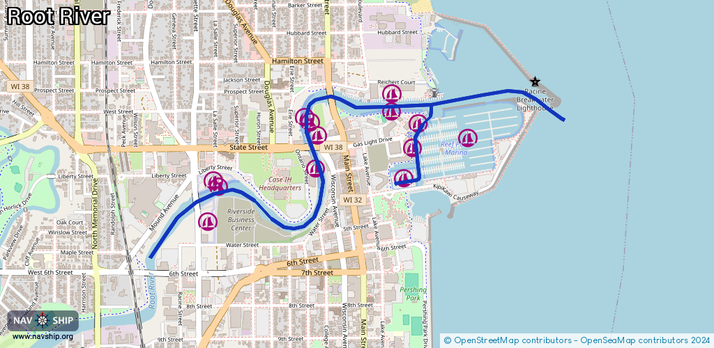
Route:
Please wait, loading route graphic...
Request waterway overview map with symbol legend here (Link).
Information about data associated with this body of water (14 available):
Data by OpenSeaMap (c) OSM contributors, www.openseamap.org
| # | Kind | Coordinates | Name | Information |
|---|---|---|---|---|
| 1 | Marina | 42.73242,-87.77473 | 2021-04-11T15:26:07Z | Reef Point Marina https://reefpointmarina.org/ |
| 2 | Marina | 42.7332,-87.78108 | 2022-01-21T05:14:38Z | |
| 3 | Marina | 42.7342,-87.78044 | 2025-08-17T14:24:29Z | River's End Marina - Operated By Racine Riverside Marine https://riversendracine.com/ |
| 4 | Marina | 42.73392,-87.78319 | 2025-08-11T23:52:33Z | Slips of Chartroom https://riversendrestaurants.com/boat-slips-at-chartroom/ |
| 5 | Marina | 42.73311,-87.78622 | 2021-02-18T06:36:02Z | |
| 6 | Marina | 42.7328,-87.78583 | 2022-01-21T05:14:38Z | |
| 7 | Marina | 42.73218,-87.78538 | 2022-01-21T05:14:38Z | |
| 8 | Marina | 42.73067,-87.78558 | 2022-01-21T05:14:38Z | |
| 9 | Marina | 42.72996,-87.79099 | 2021-09-11T03:36:28Z | |
| 10 | Marina | 42.73012,-87.7921 | 2021-09-11T03:36:28Z | Fifth Street Yacht Club |
| 11 | Marina | 42.73284,-87.7791 | 2021-04-11T15:26:07Z | |
| 12 | Marina | 42.73171,-87.77962 | 2021-04-11T15:26:07Z | |
| 13 | Marina | 42.73013,-87.78028 | 2021-04-11T15:26:07Z | |
| 14 | Fuel station | 42.73511,-87.78443 | 2023-09-16T12:48:57Z | W.H. Pugh Co. |