Waterway information

Kind:
Inland
Driving areas:
🇳🇱 Netherlands🌊 North Sea
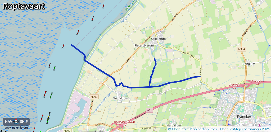
Length:
7.9 km¹
¹River kilometers or bank length recorded in NavShip, including river arms and harbor entrances.
Availability:
Completely recorded
Recent Update: 06.06.2025²
² This date indicates when an adjustment last took place in the course of the body of water
Recorded:
Locks: 0
Harbours / marinas: 0
Bridges: 6
Berths: 0
Slipways: 0
Fuelstations: 0
Route:
Please wait, loading route graphic...
Request waterway overview map with symbol legend here (Link).
Information about data associated with this body of water (6 available):
Data by OpenSeaMap (c) OSM contributors, www.openseamap.org
| # | Kind | Coordinates | Name | Information |
|---|---|---|---|---|
| 1 | Bridge | 53.20011,5.45832 | Unknown | Clearance height: 2025-05-22T17:52:57Z m fixed |
| 2 | Bridge | 53.1996,5.45768 | Unknown | Clearance height: 2025-05-22T17:52:57Z m fixed |
| 3 | Bridge | 53.19818,5.45609 | Unknown | Clearance height: 2025-05-22T17:52:57Z m fixed |
| 4 | Bridge | 53.19941,5.45758 | Unknown | Clearance height: 2025-05-23T16:44:21Z m fixed |
| 5 | Bridge | 53.20411,5.45328 | Unknown | Clearance height: 2025-05-24T07:46:03Z m fixed |
| 6 | Bridge | 53.20396,5.4537 | Unknown | Clearance height: 2025-05-24T07:46:03Z m fixed |