Waterway information

Kind:
Inland
Driving areas:
🇫🇷 France🇨🇭 Switzerland
Length:
65.7 km¹
¹River kilometers or bank length recorded in NavShip, including river arms and harbor entrances.
Availability:
Completely recorded
Recent Update: 25.07.2023²
² This date indicates when an adjustment last took place in the course of the body of water
Recorded:
Locks: 2
Harbours / marinas: 3
Bridges: 0
Berths: 0
Slipways: 1
Fuelstations: 0
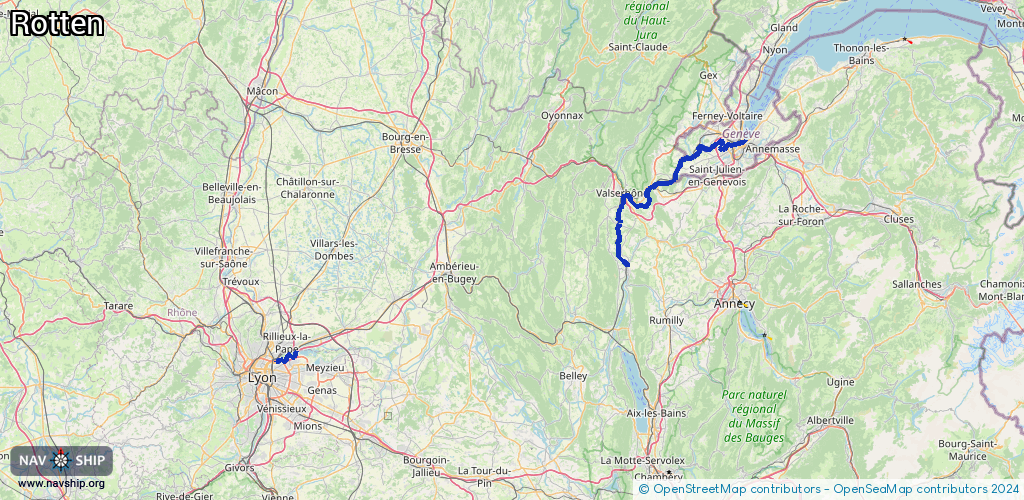
Route:
Please wait, loading route graphic...
Request waterway overview map with symbol legend here (Link).
Information about data associated with this body of water (6 available):
Data by OpenSeaMap (c) OSM contributors, www.openseamap.org
| # | Kind | Coordinates | Name | Information |
|---|---|---|---|---|
| 1 | Marina | 46.21,6.15693 | 2026-02-17T12:44:26Z | Phare des Pâquis |
| 2 | Marina | 46.20801,6.15599 | 2026-02-16T19:34:52Z | Phare des Eaux-Vives |
| 3 | Marina | 46.20546,6.15596 | 2026-02-17T13:58:03Z | Jetée des Eaux-Vives [email protected] +41 22 388 55 50 https://www.ge.ch/navigation-capitainerie/ports |
| 4 | Slipway | 46.20565,6.15693 | Unknown | 2021-01-03T16:27:46Z |
| 5 | Lock | 45.7913,4.87924 | Unknown | |
| 6 | Lock | 46.20474,6.13535 | Unknown |