Waterway information

Kind:
Inland
Driving areas:
🇩🇪 Germany
Length:
1.8 km¹
¹River kilometers or bank length recorded in NavShip, including river arms and harbor entrances.
Availability:
Completely recorded
Recent Update: 12.05.2023²
² This date indicates when an adjustment last took place in the course of the body of water
Recorded:
Locks: 0
Harbours / marinas: 5
Bridges: 0
Berths: 1
Slipways: 2
Fuelstations: 1
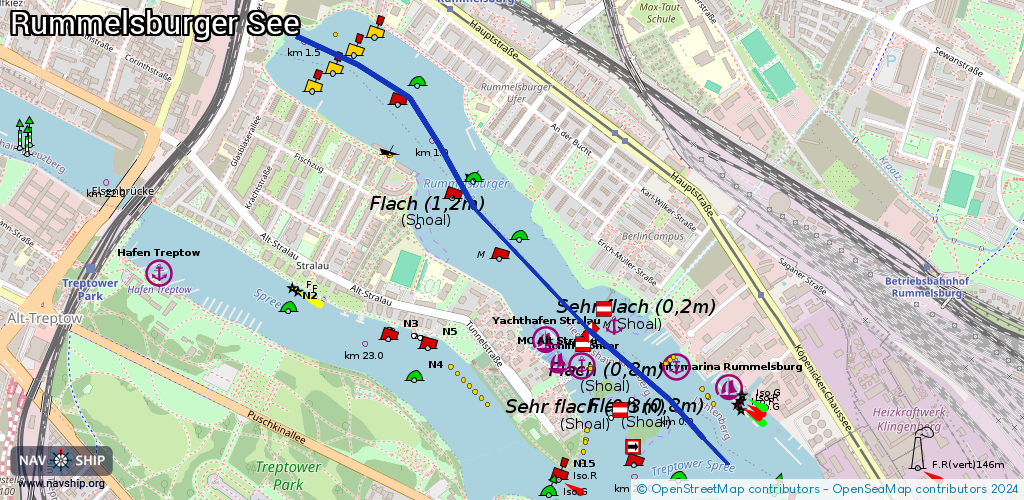
Route:
Please wait, loading route graphic...
Request waterway overview map with symbol legend here (Link).
Information about data associated with this body of water (9 available):
Data by OpenSeaMap (c) OSM contributors, www.openseamap.org
| # | Kind | Coordinates | Name | Information |
|---|---|---|---|---|
| 1 | Marina | 52.49131,13.48292 | 2023-11-09T03:31:56Z | Hafen Schiffskontor [email protected] +49 30 246479960 https://www.schiffskontor.de/ |
| 2 | Marina | 52.49189,13.48132 | 2021-01-22T19:36:34Z | Yachthafen Stralau [email protected] +49 30 2919345 http://www.yachthafen-stralau.de/ |
| 3 | Marina | 52.49142,13.48194 | 2020-11-14T13:32:58Z | MC Alt Stralau [email protected] +49 30 29048388 |
| 4 | Marina | 52.49127,13.48698 | 2014-09-07T12:49:53Z | |
| 5 | Marina | 52.49074,13.48924 | 2021-08-20T08:41:15Z | Citymarina Rummelsburg Gastliegeplätze für Boote bis 15 Meter Länge, Hafenküche mit guter Küche, Bootsvermietung, Slipanlage, Abwasserentsorgung, Verkehrsanbindung über Tram ca. 500 m, Hafenmeister: 030/422199299 [email protected] +49 30 422199299 https://citymarina-berlin.de/ |
| 6 | Slipway | 52.49162,13.48094 | small_craft_facility | 2017-01-23T09:38:02Z |
| 7 | Slipway | 52.49118,13.48894 | small_craft_facility | 2013-04-11T11:25:21Z |
| 8 | Berth | 52.49234,13.48431 | 2016-04-03T20:27:39Z | |
| 9 | Fuel station | 52.492,13.48687 | 2024-11-03T09:53:02Z | Bunkerboot Spree Keine Service für Sportboote Mobil Mo-Fr 10:00-16:00 +49 170 2837725 https://www.nwb-bunker.de/ |