Waterway information

Kind:
Inland
Driving areas:
🌊 Atlantic Ocean🇨🇦 Canada🇺🇸 United States of America
Length:
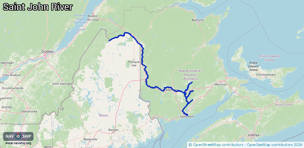
592 km¹
¹River kilometers or bank length recorded in NavShip, including river arms and harbor entrances.
Availability:
Completely recorded
Recent Update: 02.09.2025²
² This date indicates when an adjustment last took place in the course of the body of water
Recorded:
Locks: 0
Harbours / marinas: 11
Bridges: 0
Berths: 0
Slipways: 1
Fuelstations: 1
Route:
Please wait, loading route graphic...
Request waterway overview map with symbol legend here (Link).
Information about data associated with this body of water (13 available):
Data by OpenSeaMap (c) OSM contributors, www.openseamap.org
| # | Kind | Coordinates | Name | Information |
|---|---|---|---|---|
| 1 | Marina | 45.27935,-66.15429 | 2023-03-02T21:36:11Z | Saint John Marina [email protected] +1 506 7388484 https://saintjohnmarina.ca/ |
| 2 | Marina | 45.78815,-66.14432 | 2024-10-18T14:22:46Z | |
| 3 | Marina | 45.91496,-66.08891 | 2025-08-05T15:45:51Z | The Bedroom |
| 4 | Marina | 45.29629,-66.18045 | 2023-03-02T21:36:11Z | Martinon Yacht Club [email protected] https://www.martinonyc.ca |
| 5 | Marina | 45.27488,-66.0396 | 2022-09-07T07:40:19Z | Saint John Refinery Terminal |
| 6 | Marina | 46.73656,-67.70816 | 2026-01-05T04:41:13Z | |
| 7 | Marina | 45.9952,-67.23295 | 2025-04-28T01:22:26Z | |
| 8 | Marina | 45.94739,-66.88185 | 2024-10-22T15:12:23Z | York Centennial Sailboat Marina |
| 9 | Marina | 45.96749,-66.74464 | 2023-10-18T15:22:37Z | |
| 10 | Marina | 45.96754,-66.74539 | 2023-10-18T15:22:37Z | |
| 11 | Marina | 45.97399,-66.89033 | 2024-01-08T23:19:37Z | Mactaquac Park Marina |
| 12 | Slipway | 45.27953,-66.1552 | Unknown | 2019-04-22T19:45:33Z |
| 13 | Fuel station | 45.27989,-66.15468 | 2023-03-02T21:36:11Z |