Waterway information

Kind:
Inland
Driving areas:
🇨🇦 Canada🇺🇸 United States of America
Length:
533.3 km¹
¹River kilometers or bank length recorded in NavShip, including river arms and harbor entrances.
Availability:
Completely recorded
Recent Update: 24.06.2025²
² This date indicates when an adjustment last took place in the course of the body of water
Recorded:
Locks: 1
Harbours / marinas: 21
Bridges: 0
Berths: 2
Slipways: 0
Fuelstations: 3
Route:
Please wait, loading route graphic...
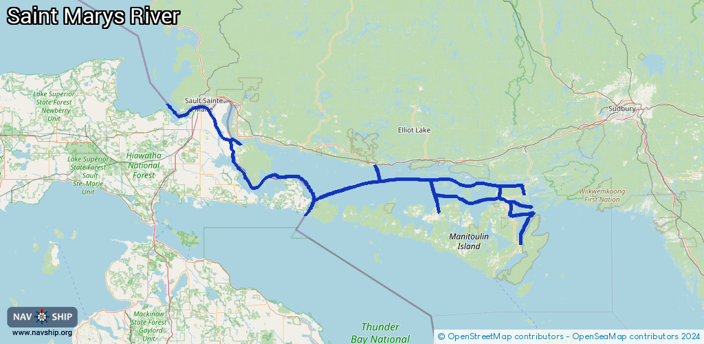
Request waterway overview map with symbol legend here (Link).
Information about data associated with this body of water (27 available):
Data by OpenSeaMap (c) OSM contributors, www.openseamap.org
| # | Kind | Coordinates | Name | Information |
|---|
| 1 | Marina | 46.17945,-82.96604 | 2024-05-28T18:16:28Z | Blind River Marina
https://www.brmarinepark.ca/marina |
| 2 | Marina | 46.29799,-83.79036 | 2024-08-09T19:35:06Z | |
| 3 | Marina | 45.91027,-82.259 | 2024-08-09T13:27:30Z | |
| 4 | Marina | 45.90994,-82.25678 | 2024-08-09T13:27:30Z | |
| 5 | Marina | 45.97205,-81.90304 | 2024-05-27T12:44:30Z | Harbor Vue Marina
https://www.harborvue.ca/ |
| 6 | Marina | 45.98229,-81.9265 | 2024-05-27T12:51:14Z | Little Current Government Dock |
| 7 | Marina | 45.98441,-81.92854 | 2024-05-27T12:44:30Z | Boyle Marine
http://www.boylemarine.com/ |
| 8 | Marina | 45.98626,-81.93169 | 2024-09-06T15:54:23Z | Spider Bay Marina
https://www.townofnemi.on.ca/p/spider-bay-marina |
| 9 | Marina | 46.06784,-81.78121 | 2024-08-12T20:14:33Z | |
| 10 | Marina | 46.32455,-83.94411 | 2024-08-14T17:03:35Z | |
| 11 | Marina | 45.92062,-82.46176 | 2024-05-27T13:11:45Z | Gore Bay Marina
https://www.gorebay.ca/en/community/gore-bay-marina |
| 12 | Marina | 46.29526,-84.03785 | 2024-02-29T22:12:12Z | |
| 13 | Marina | 46.50802,-84.33547 | 2021-04-02T22:44:56Z | St. Marys River Marina |
| 14 | Marina | 46.50114,-84.34019 | 2024-12-21T13:39:38Z | Plant Basin
https://www.nps.gov/subjects/nationalregister/index.htm |
| 15 | Marina | 46.49926,-84.33724 | 2023-01-31T00:20:08Z | George Kemp Downtown Marina
+1-906-632-3658
https://www.saulthistoricsites.com/kemp-marina/ |
| 16 | Marina | 46.50134,-84.30615 | 2025-03-24T16:28:48Z | Bellevue Marina |
| 17 | Marina | 46.47051,-84.29949 | 2023-11-29T12:16:54Z | Charles T. Harvey Marina
https://www.saultcity.com/parksrec/page/charles-t-harvey-boat-launch |
| 18 | Marina | 45.92586,-83.11335 | 2024-08-14T13:42:17Z | Meldrum Marina |
| 19 | Marina | 46.52755,-84.58226 | 2025-04-06T18:12:35Z | |
| 20 | Marina | 46.25445,-83.55164 | 2025-04-22T22:59:20Z | Thessalon Marina |
| 21 | Marina | 45.74271,-81.80443 | 2024-07-18T19:54:51Z | |
| 22 | Berth | 46.50068,-84.33866 | 2024-12-13T15:00:40Z | USCGC Buckthorn
BUCKTHORN is the oldest cutter on the Great Lakes. The area of responsibility for the BUCKTHORN is from Whitefish Point through the Saint Marie's River, 65 miles of integral river that connects Lake Huron to Lake Superior to Cedarville, MI. |
| 23 | Berth | 46.50078,-84.33833 | 2024-12-13T15:00:40Z | USCGC Katmai Bay
The U.S. Coast Guard Cutter KATMAI BAY (WTGB-101) is a 140 foot Bay Class Icebreaking Tug homeported in Sault Sainte Marie, MI. Unit missions include icebreaking, Homeland Security patrols, Light House projects, Law Enforcement, and Public Affairs. |
| 24 | Fuel station | 45.98079,-81.9252 | 2025-07-25T20:33:20Z | The Port of Little Current Service Dock |
| 25 | Fuel station | 45.98616,-81.93093 | 2024-09-06T15:54:23Z | |
| 26 | Fuel station | 46.49995,-84.3372 | 2024-07-19T17:45:25Z | |
| 27 | Lock | 46.50291,-84.35174 | Unknown | |