Waterway information

Kind:
Inland
Driving areas:
🌊 Atlantic Ocean🇺🇸 United States of America
Length:
18.2 km¹
¹River kilometers or bank length recorded in NavShip, including river arms and harbor entrances.
Availability:
Completely recorded
Recent Update: 18.01.2024²
² This date indicates when an adjustment last took place in the course of the body of water
Recorded:
Locks: 0
Harbours / marinas: 10
Bridges: 0
Berths: 0
Slipways: 1
Fuelstations: 0
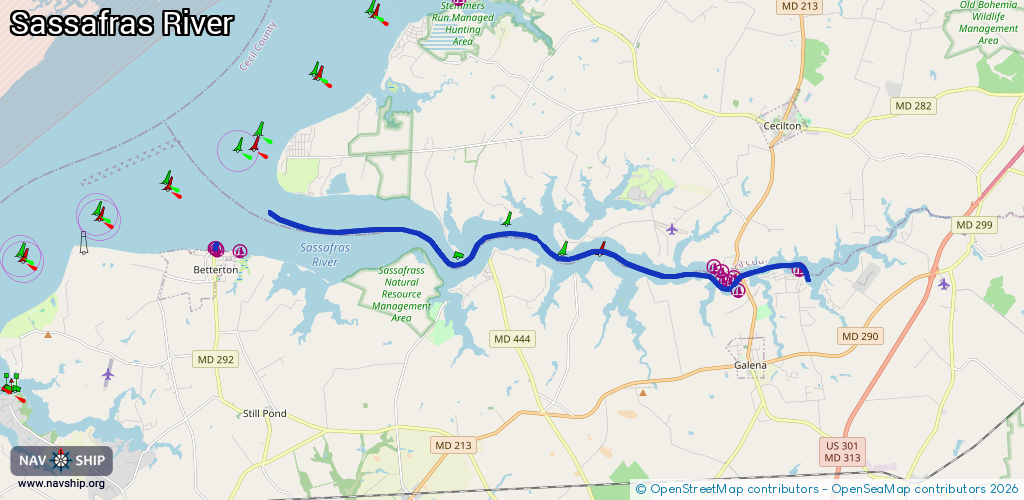
Route:
Please wait, loading route graphic...
Request waterway overview map with symbol legend here (Link).
Information about data associated with this body of water (11 available):
Data by OpenSeaMap (c) OSM contributors, www.openseamap.org
| # | Kind | Coordinates | Name | Information |
|---|---|---|---|---|
| 1 | Marina | 39.37095,-76.06172 | 2021-01-04T01:10:43Z | |
| 2 | Marina | 39.37133,-76.0625 | 2021-01-04T01:10:43Z | |
| 3 | Marina | 39.37137,-76.06197 | 2021-01-04T01:10:43Z | |
| 4 | Marina | 39.36576,-75.86194 | 2020-05-19T21:33:26Z | |
| 5 | Marina | 39.36414,-75.88444 | 2024-06-19T23:00:14Z | Sassafras Harbor Marina +1 410-275-2666 |
| 6 | Marina | 39.36288,-75.88575 | 2024-06-19T23:00:14Z | https://www.sassafrasharbormarina.com/ |
| 7 | Marina | 39.36005,-75.88227 | 2020-05-19T21:33:26Z | |
| 8 | Marina | 39.36348,-75.88789 | 2024-06-19T23:00:14Z | Granary Marina +1 443-480-6138 https://granarymarina.com/ |
| 9 | Marina | 39.3653,-75.88872 | 2024-06-19T23:00:14Z | Duffy Creek Marina https://www.duffycreekmarina.com/ |
| 10 | Marina | 39.3668,-75.89023 | 2024-06-19T23:00:14Z | Skipjack Cove Yachting Resort +1 410-275-2141 https://www.skipjackcovemd.com/ |
| 11 | Slipway | 39.371,-76.0625 | Unknown | 2021-01-04T00:52:32Z |