Waterway information

Kind:
Inland
Driving areas:
🇩🇪 Germany
Length:
3.7 km¹
¹River kilometers or bank length recorded in NavShip, including river arms and harbor entrances.
Availability:
Completely recorded
Recent Update: 05.07.2024²
² This date indicates when an adjustment last took place in the course of the body of water
Recorded:
Locks: 0
Harbours / marinas: 2
Bridges: 3
Berths: 0
Slipways: 1
Fuelstations: 0
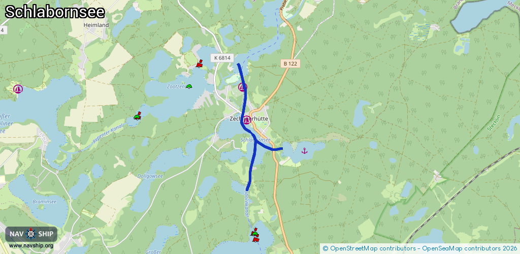
Route:
Please wait, loading route graphic...
Request waterway overview map with symbol legend here (Link).
Information about data associated with this body of water (6 available):
Data by OpenSeaMap (c) OSM contributors, www.openseamap.org
| # | Kind | Coordinates | Name | Information |
|---|---|---|---|---|
| 1 | Marina | 53.15466,12.87314 | 2012-10-21T13:45:45Z | Hafen Zechlinerhütte |
| 2 | Marina | 53.16139,12.87185 | 2025-05-19T09:14:41Z | Privathafen Am Jagowkanal |
| 3 | Bridge | 53.14206,12.87409 | 5.3 | Clearance height: 2019-04-13T16:37:42Z m Maximum passage width: 3.90 m Movable bridge (e.g. lifting bridge or drawbridge) fixed |
| 4 | Bridge | 53.15608,12.8718 | 12 | Clearance height: 2016-09-14T11:59:21Z m Maximum passage width: 4.2 m Movable bridge (e.g. lifting bridge or drawbridge) fixed |
| 5 | Bridge | 53.14872,12.88215 | Unknown | Clearance height: 2020-10-29T16:12:43Z m Maximum passage width: 3.70 m Movable bridge (e.g. lifting bridge or drawbridge) fixed |
| 6 | Slipway | 53.15604,12.87094 | small_craft_facility | 2023-05-01T14:07:51Z |