Waterway information

Kind:
Lower
Driving areas:
🇩🇪 Germany
Length:
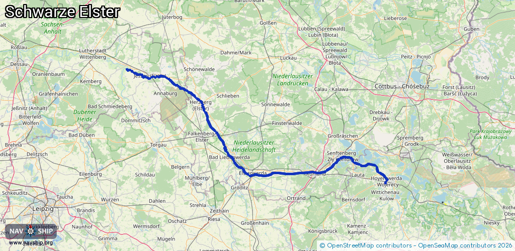
134.5 km¹
¹River kilometers or bank length recorded in NavShip, including river arms and harbor entrances.
Availability:
Completely recorded
Recent Update: 09.04.2025²
² This date indicates when an adjustment last took place in the course of the body of water
Recorded:
Locks: 0
Harbours / marinas: 2
Bridges: 2
Berths: 0
Slipways: 6
Fuelstations: 0
Route:
Please wait, loading route graphic...
Request waterway overview map with symbol legend here (Link).
Information about data associated with this body of water (10 available):
Data by OpenSeaMap (c) OSM contributors, www.openseamap.org
| # | Kind | Coordinates | Name | Information |
|---|---|---|---|---|
| 1 | Marina | 51.54736,13.36912 | 2021-05-10T08:59:37Z | Kahnanlegestelle Kleiner Spreewald |
| 2 | Marina | 51.45932,13.54649 | 2014-09-04T13:12:38Z | |
| 3 | Bridge | 51.60601,13.31203 | Unknown | Clearance height: 2012-11-27T13:19:16Z m fixed |
| 4 | Bridge | 51.63601,13.27689 | Unknown | Clearance height: 2012-11-27T13:19:17Z m fixed |
| 5 | Slipway | 51.5358,13.37486 | small_craft_facility | 2020-06-12T14:29:39Z Ein- und Aussetzstelle / Umtragemöglichkeit zur Kleinen Elster |
| 6 | Slipway | 51.53612,13.37545 | small_craft_facility | 2013-04-08T16:46:31Z Ein- und Aussetzstelle Kanu / Umtragemöglichkeit zur Schwarzen Elster |
| 7 | Slipway | 51.55034,13.36954 | small_craft_facility | 2021-05-10T08:59:37Z Ein- und Aussetzstelle Kanu |
| 8 | Slipway | 51.55086,13.36882 | small_craft_facility | 2021-05-10T08:59:37Z Ein- und Aussetzstelle Kanu |
| 9 | Slipway | 51.52004,13.39121 | small_craft_facility | 2012-11-27T13:19:16Z |
| 10 | Slipway | 51.65086,13.27091 | small_craft_facility | 2012-11-27T13:19:17Z |