Waterway information

Kind:
Inland
Driving areas:
🇩🇪 Germany
Length:
6.6 km¹
¹River kilometers or bank length recorded in NavShip, including river arms and harbor entrances.
Availability:
Completely recorded
Recent Update: 31.03.2025²
² This date indicates when an adjustment last took place in the course of the body of water
Recorded:
Locks: 0
Harbours / marinas: 5
Bridges: 1
Berths: 0
Slipways: 1
Fuelstations: 0
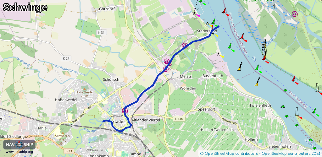
Route:
Please wait, loading route graphic...
Request waterway overview map with symbol legend here (Link).
Information about data associated with this body of water (7 available):
Data by OpenSeaMap (c) OSM contributors, www.openseamap.org
| # | Kind | Coordinates | Name | Information |
|---|---|---|---|---|
| 1 | Marina | 53.60303,9.4794 | 2024-03-19T12:53:36Z | Stadthafen Stade +49 151 15040495 https://www.stadtwerke-stade.de/index.php?option=com_content&view=article&id=37&Itemid=49 |
| 2 | Marina | 53.61677,9.50193 | 2023-04-03T06:44:39Z | Motor- und Yachtclub Stade e.V. - Oberhafen [email protected] +49 4141 3585 https://www.myc-stade.com/ |
| 3 | Marina | 53.61829,9.50335 | 2024-01-28T11:07:41Z | Motor- und Yachtclub Stade e.V. - Unterhafen [email protected] +49 4141 3585 https://www.myc-stade.com/ |
| 4 | Marina | 53.61918,9.50208 | 2024-01-28T11:07:41Z | Sportclub Diamant Stade [email protected] +49 4141 2157 https://www.sc-diamant.de/162/Wassersport/Sportarten/Wassersport.html |
| 5 | Marina | 53.62429,9.51204 | 2019-03-28T17:42:40Z | Segler-Verein Stade +49 171 3621695 https://www.seglerverein-stade.de/ |
| 6 | Bridge | 53.61579,9.49967 | Unknown | Clearance height: 2024-05-02T18:35:31Z m Maximum passage width: 6.3 m Movable bridge (e.g. lifting bridge or drawbridge) drawbridge |
| 7 | Slipway | 53.61702,9.50258 | small_craft_facility | 2013-07-08T08:03:32Z |