Waterway information

Kind:
Inland
Driving areas:
🇩🇪 Germany
Length:
5.5 km¹
¹River kilometers or bank length recorded in NavShip, including river arms and harbor entrances.
Availability:
Completely recorded
Recent Update: 22.06.2023²
² This date indicates when an adjustment last took place in the course of the body of water
Recorded:
Locks: 0
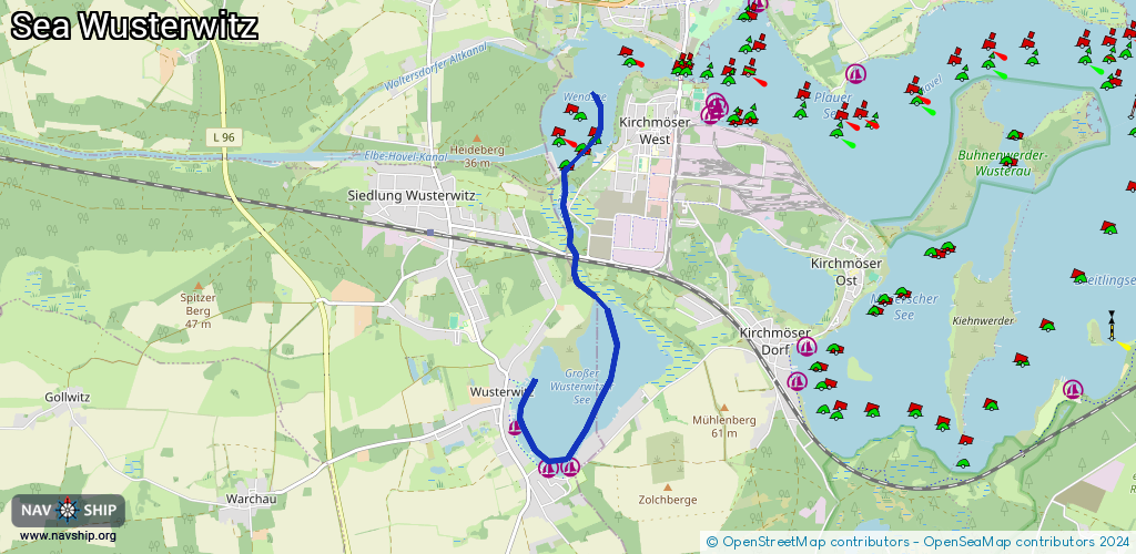
Harbours / marinas: 3
Bridges: 2
Berths: 0
Slipways: 0
Fuelstations: 0
Route:
Please wait, loading route graphic...
Request waterway overview map with symbol legend here (Link).
Information about data associated with this body of water (5 available):
Data by OpenSeaMap (c) OSM contributors, www.openseamap.org
| # | Kind | Coordinates | Name | Information |
|---|---|---|---|---|
| 1 | Marina | 52.36707,12.38606 | 2013-01-15T11:32:15Z | Anleger Residenz am See - Wusterwitz [email protected] +49 33839 71926 http://www.hotel-wusterwitz.de |
| 2 | Marina | 52.36303,12.39128 | 2012-12-20T14:12:32Z | Marina Centro Vita am See +49 33839 71400 http://www.centrovita.de/ |
| 3 | Marina | 52.36315,12.39465 | 2023-01-21T17:49:34Z | Marina Campingplatz Böhmer [email protected] +49 1769 4420409 http://www.campingplatz-wusterwitz.de/ |
| 4 | Bridge | 52.38285,12.39535 | 7 | Clearance height: 2015-05-18T13:11:55Z m Maximum passage width: 3.86 m Movable bridge (e.g. lifting bridge or drawbridge) fixed |
| 5 | Bridge | 52.38326,12.39547 | 5.50 | Clearance height: 2015-05-18T13:11:56Z m Maximum passage width: 3.94 m Movable bridge (e.g. lifting bridge or drawbridge) fixed |