Waterway information

Kind:
Inland
Driving areas:
🌊 Atlantic Ocean🇺🇸 United States of America
Length:
24.1 km¹
¹River kilometers or bank length recorded in NavShip, including river arms and harbor entrances.
Availability:
Completely recorded
Recent Update: 10.06.2025²
² This date indicates when an adjustment last took place in the course of the body of water
Recorded:
Locks: 0
Harbours / marinas: 6
Bridges: 1
Berths: 1
Slipways: 1
Fuelstations: 0
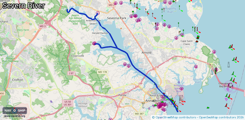
Route:
Please wait, loading route graphic...
Request waterway overview map with symbol legend here (Link).
Information about data associated with this body of water (9 available):
Data by OpenSeaMap (c) OSM contributors, www.openseamap.org
| # | Kind | Coordinates | Name | Information |
|---|---|---|---|---|
| 1 | Marina | 39.07582,-76.57238 | 2025-12-07T22:20:46Z | |
| 2 | Marina | 38.98258,-76.47892 | 2020-05-19T21:33:26Z | Santee Basin |
| 3 | Marina | 39.01707,-76.52819 | 2026-02-20T19:00:38Z | |
| 4 | Marina | 39.01919,-76.53345 | 2020-05-19T21:33:26Z | Clements Creek |
| 5 | Marina | 39.04215,-76.57671 | 2023-07-20T21:00:37Z | |
| 6 | Marina | 39.04196,-76.57773 | 2022-09-18T18:53:22Z | Smith's Marina |
| 7 | Bridge | 39.0066,-76.50366 | 123 | Clearance height: 2025-12-12T02:33:43Z m Maximum passage width: 80 m Movable bridge (e.g. lifting bridge or drawbridge) fixed |
| 8 | Slipway | 39.07582,-76.57238 | harbour | 2025-12-07T22:20:46Z |
| 9 | Berth | 38.9756,-76.46688 | 2021-05-17T03:53:58Z | Annapolis Harbor, MD, Middle Ground Anchroage Area |