Waterway information

Kind:
Inland
Driving areas:
🌊 Atlantic Ocean🇮🇪 Ireland🇬🇧 United Kingdom
Length:
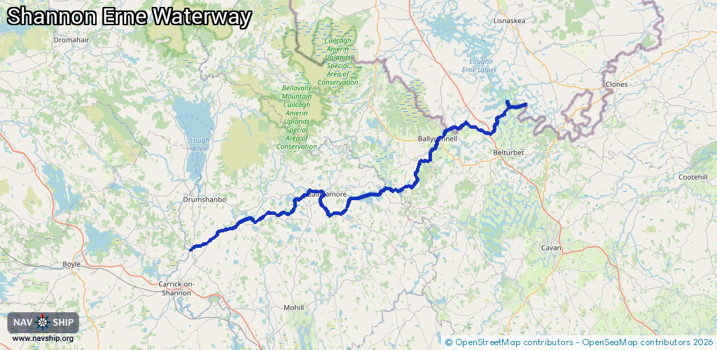
65.9 km¹
¹River kilometers or bank length recorded in NavShip, including river arms and harbor entrances.
Availability:
Completely recorded
Recent Update: 09.04.2025²
² This date indicates when an adjustment last took place in the course of the body of water
Recorded:
Locks: 15
Harbours / marinas: 7
Bridges: 0
Berths: 0
Slipways: 0
Fuelstations: 0
Route:
Please wait, loading route graphic...
Request waterway overview map with symbol legend here (Link).
Information about data associated with this body of water (22 available):
Data by OpenSeaMap (c) OSM contributors, www.openseamap.org
| # | Kind | Coordinates | Name | Information |
|---|---|---|---|---|
| 1 | Marina | 54.11611,-7.58302 | 2021-12-22T20:02:55Z | Ballyconnell Moorings |
| 2 | Marina | 54.11459,-7.58453 | 2020-10-03T13:32:03Z | |
| 3 | Marina | 54.11164,-7.58415 | 2020-10-03T13:32:03Z | |
| 4 | Marina | 54.05623,-7.69274 | 2022-07-02T02:58:32Z | Houghton's Shore mooring |
| 5 | Marina | 54.05479,-7.80746 | 2020-12-30T23:37:13Z | Ballinamore Mooring |
| 6 | Marina | 53.99042,-8.06424 | 2020-08-31T10:40:42Z | Leitrim Quay |
| 7 | Marina | 53.98918,-8.06688 | 2020-08-31T10:40:42Z | Leitrim Marina |
| 8 | Lock | 54.1307,-7.52045 | Unknown | |
| 9 | Lock | 54.11812,-7.57539 | Unknown | |
| 10 | Lock | 54.06169,-7.63304 | Unknown | |
| 11 | Lock | 54.02984,-7.79111 | Unknown | |
| 12 | Lock | 54.04699,-7.81413 | Unknown | |
| 13 | Lock | 54.04911,-7.85086 | Unknown | |
| 14 | Lock | 54.03082,-7.90678 | Unknown | |
| 15 | Lock | 54.01152,-8.00198 | Unknown | |
| 16 | Lock | 54.01119,-8.00498 | Unknown | |
| 17 | Lock | 54.01104,-8.00807 | Unknown | |
| 18 | Lock | 54.00799,-8.01623 | Unknown | |
| 19 | Lock | 54.0037,-8.02038 | Unknown | |
| 20 | Lock | 54.00207,-8.02522 | Unknown | |
| 21 | Lock | 53.99501,-8.04537 | Unknown | |
| 22 | Lock | 53.99317,-8.05696 | Unknown |