Waterway information

Kind:
Sea
Driving areas:
🇮🇹 Italy🌊 Sea Mediterranean
Length:
112.8 km¹
¹River kilometers or bank length recorded in NavShip, including river arms and harbor entrances.
Availability:
Completely recorded
Recent Update: 02.09.2025²
² This date indicates when an adjustment last took place in the course of the body of water
Recorded:
Locks: 3
Harbours / marinas: 5
Bridges: 0
Berths: 0
Slipways: 1
Fuelstations: 1
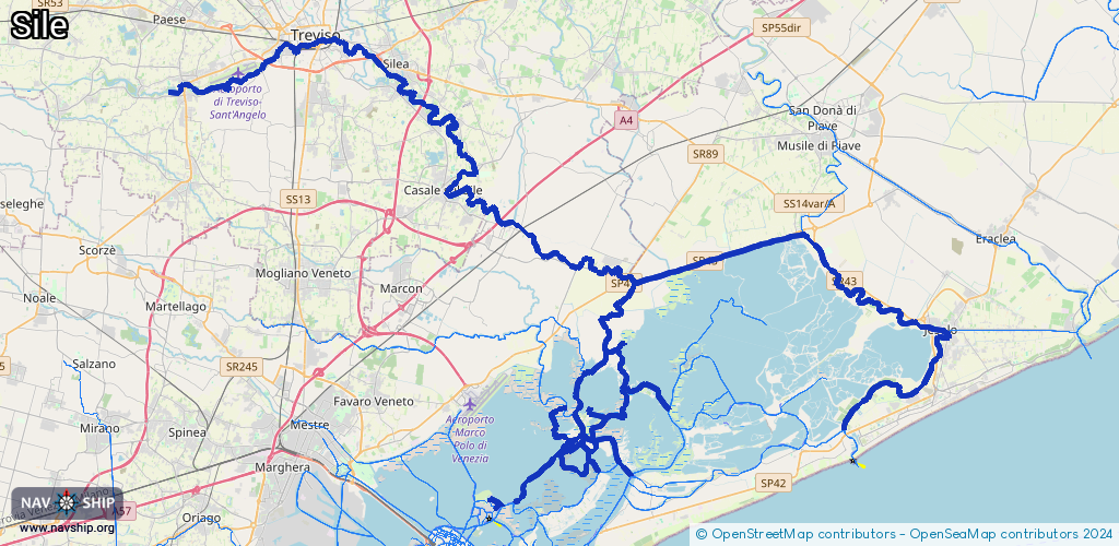
Route:
Please wait, loading route graphic...
Request waterway overview map with symbol legend here (Link).
Information about data associated with this body of water (9 available):
Data by OpenSeaMap (c) OSM contributors, www.openseamap.org
| # | Kind | Coordinates | Name | Information |
|---|---|---|---|---|
| 1 | Marina | 45.5555,12.44326 | H-FARM Campus Marina | H-FARM Campus Marina Surveillance and marine assistance, tourism accommodation in apartments and restaurants and bistrot inside the campus Mo-So 7:00-21:00 [email protected] +39 0422 789611 https://www.h-farm.com/en/marina-venice-lagoon-portegrandi-nautical-startups-berths-boats |
| 2 | Marina | 45.63667,12.30434 | 2024-09-18T09:44:50Z | Le Boat |
| 3 | Marina | 45.63628,12.30361 | 2024-09-18T09:44:50Z | houseboat |
| 4 | Marina | 45.64044,12.29795 | 2024-09-18T09:45:54Z | Porto di Casier |
| 5 | Marina | 45.64865,12.29554 | 2024-07-01T15:22:42Z | Porto di Silea |
| 6 | Slipway | 45.52252,12.63371 | small_craft_facility | 2013-05-12T15:21:48Z by car |
| 7 | Fuel station | 45.48734,12.41767 | 2024-06-04T17:21:09Z | Total Erg |
| 7 | Fuel station | 45.48734,12.41767 | 2024-06-04T17:21:09Z | Total Erg |
| 8 | Lock | 45.65168,12.2875 | Unknown | |
| 9 | Lock | 45.49195,12.57673 | Unknown |