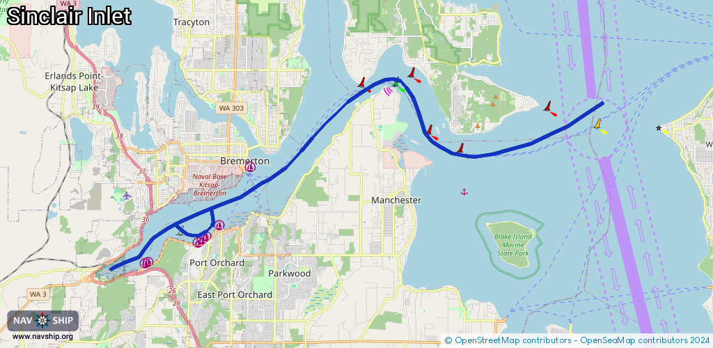
Waterway information

Kind:
Inland
Driving areas:
🇺🇸 United States of America
Length:
25 km¹
¹River kilometers or bank length recorded in NavShip, including river arms and harbor entrances.
Availability:
Completely recorded
Recent Update: 05.03.2024²
² This date indicates when an adjustment last took place in the course of the body of water
Recorded:
Locks: 0
Harbours / marinas: 6
Bridges: 0
Berths: 0
Slipways: 2
Fuelstations: 1
Route:
Please wait, loading route graphic...
Request waterway overview map with symbol legend here (Link).
Information about data associated with this body of water (9 available):
Data by OpenSeaMap (c) OSM contributors, www.openseamap.org
| # | Kind | Coordinates | Name | Information |
|---|---|---|---|---|
| 1 | Marina | 47.53151,-122.67263 | 2025-11-05T06:47:49Z | Suldan's Boat Works +1-360-876-4435 |
| 2 | Marina | 47.53077,-122.67363 | 2025-11-05T06:47:49Z | Kitsap Marina +1-360-895-2193 https://www.kitsapmarina.com/ |
| 3 | Marina | 47.54341,-122.63747 | 2023-12-29T02:34:44Z | Port Orchard Marina https://www.portofbremerton.org/port-orchard-marina |
| 4 | Marina | 47.53967,-122.64352 | 2023-12-29T16:08:44Z | Port Orchard Railway Marina https://www.portorchardrailwaymarina.com/index.php |
| 5 | Marina | 47.53855,-122.64583 | 2023-12-29T16:13:56Z | Port Orchard Yacht Club https://poyc.org/ |
| 6 | Marina | 47.53769,-122.64769 | 2023-12-29T16:13:56Z | Yachtfish Marine https://yachtfishmarine.com/ |
| 7 | Slipway | 47.5309,-122.67389 | small_craft_facility | 2023-12-30T12:41:55Z |
| 8 | Slipway | 47.54125,-122.6403 | small_craft_facility | 2023-12-29T12:21:24Z Water Street Boat Launch |
| 9 | Fuel station | 47.54336,-122.63924 | 2023-12-29T02:34:44Z |