Waterway information

Kind:
Inland
Driving areas:
🇳🇱 Netherlands
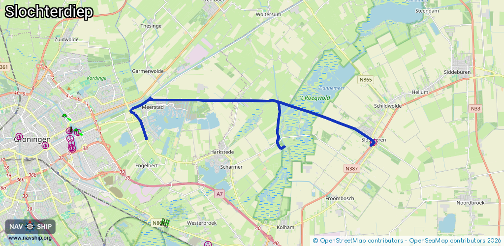
Length:
16.4 km¹
¹River kilometers or bank length recorded in NavShip, including river arms and harbor entrances.
Availability:
Completely recorded
Recent Update: 01.11.2021²
² This date indicates when an adjustment last took place in the course of the body of water
Recorded:
Locks: 1
Harbours / marinas: 1
Bridges: 6
Berths: 0
Slipways: 0
Fuelstations: 0
Route:
Please wait, loading route graphic...
Request waterway overview map with symbol legend here (Link).
Information about data associated with this body of water (8 available):
Data by OpenSeaMap (c) OSM contributors, www.openseamap.org
| # | Kind | Coordinates | Name | Information |
|---|---|---|---|---|
| 1 | Marina | 53.21765,6.80599 | 2022-06-05T13:15:26Z | Slochterhaven +31 598 416 200 http://www.vvvslochteren.nl/infogids.php?cat=recreatie&sub=Jachthavens&id=104 |
| 2 | Bridge | 53.23621,6.65053 | 6 | Clearance height: 2018-06-30T21:10:12Z m Maximum passage width: 1 m Movable bridge (e.g. lifting bridge or drawbridge) opening |
| 3 | Bridge | 53.23538,6.68412 | 5.80 | Clearance height: 2020-06-22T10:55:30Z m Maximum passage width: 0.60 m Movable bridge (e.g. lifting bridge or drawbridge) opening |
| 4 | Bridge | 53.2352,6.71176 | 6 | Clearance height: 2013-02-20T15:25:59Z m Maximum passage width: 1 m Movable bridge (e.g. lifting bridge or drawbridge) opening |
| 5 | Bridge | 53.23486,6.73877 | 5.90 | Clearance height: 2013-02-20T15:25:59Z m Maximum passage width: 1 m Movable bridge (e.g. lifting bridge or drawbridge) opening |
| 6 | Bridge | 53.23147,6.75559 | 5 | Clearance height: 2023-08-26T07:03:11Z m Maximum passage width: 1 m opening |
| 7 | Bridge | 53.22326,6.79335 | 5 | Clearance height: 2020-06-22T10:55:30Z m Maximum passage width: 1 m opening |
| 8 | Lock | 53.23605,6.6507 | Unknown |