Waterway information

Kind:
Inland
Driving areas:
🇳🇱 Netherlands
Length:
5.2 km¹
¹River kilometers or bank length recorded in NavShip, including river arms and harbor entrances.
Availability:
Completely recorded
Recent Update: 25.09.2023²
² This date indicates when an adjustment last took place in the course of the body of water
Recorded:
Locks: 1
Harbours / marinas: 2
Bridges: 6
Berths: 0
Slipways: 1
Fuelstations: 3
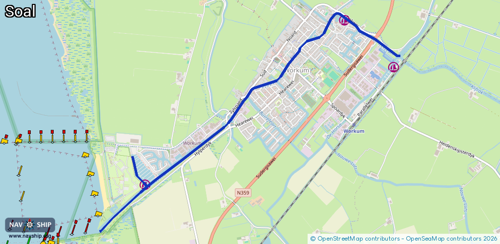
Route:
Please wait, loading route graphic...
Request waterway overview map with symbol legend here (Link).
Information about data associated with this body of water (12 available):
Data by OpenSeaMap (c) OSM contributors, www.openseamap.org
| # | Kind | Coordinates | Name | Information |
|---|---|---|---|---|
| 1 | Marina | 52.98313,5.45484 | 2023-05-27T19:56:45Z | Jachthaven Bouwsma [email protected] +31 515 542 004 https://www.jachthavenbouwsma.nl |
| 2 | Marina | 52.96571,5.41979 | 2023-05-27T19:56:33Z | Jachthaven It Soal [email protected] +31 515 542 937 https://www.itsoal.nl |
| 3 | Bridge | 52.97227,5.43439 | 7.3 | Clearance height: 2022-06-06T06:32:09Z m Maximum passage width: 2 m Movable bridge (e.g. lifting bridge or drawbridge) opening |
| 4 | Bridge | 52.97597,5.43899 | 6.99 | Clearance height: 2020-06-20T15:31:08Z m Maximum passage width: 1.33 m Movable bridge (e.g. lifting bridge or drawbridge) opening BB H12 W70 |
| 5 | Bridge | 52.9786,5.44505 | 7.82 | Clearance height: 2016-04-16T06:56:59Z m Maximum passage width: 0.88 m Movable bridge (e.g. lifting bridge or drawbridge) opening BB H8.5 W80 |
| 6 | Bridge | 52.98247,5.45173 | 6.8 | Clearance height: 2023-08-17T20:28:04Z m Maximum passage width: 0.9 m Movable bridge (e.g. lifting bridge or drawbridge) fixed BB H9 W69 |
| 7 | Bridge | 52.98077,5.45648 | Unknown | Clearance height: 2020-10-06T19:45:01Z m opening |
| 8 | Bridge | 52.98115,5.46012 | 7.55 | Clearance height: 2024-09-07T11:39:26Z m Maximum passage width: 2.52 m Movable bridge (e.g. lifting bridge or drawbridge) opening BB H24 W70 |
| 9 | Slipway | 52.96892,5.41752 | small_craft_facility | 2019-03-17T19:38:59Z |
| 10 | Fuel station | 52.9665,5.42172 | 2013-05-11T06:55:14Z | |
| 11 | Fuel station | 52.96649,5.42168 | 2013-02-15T10:04:31Z | |
| 12 | Fuel station | 52.98301,5.45562 | 2025-04-22T22:20:40Z | |
| 12 | Fuel station | 52.98301,5.45562 | 2025-04-22T22:20:40Z |