Waterway information

Kind:
Inland
Driving areas:
🇩🇪 Germany
Length:
0.7 km¹
¹River kilometers or bank length recorded in NavShip, including river arms and harbor entrances.
Availability:
Completely recorded
Recent Update: 01.09.2025²
² This date indicates when an adjustment last took place in the course of the body of water
Recorded:
Locks: 0
Harbours / marinas: 2
Bridges: 2
Berths: 0
Slipways: 3
Fuelstations: 0
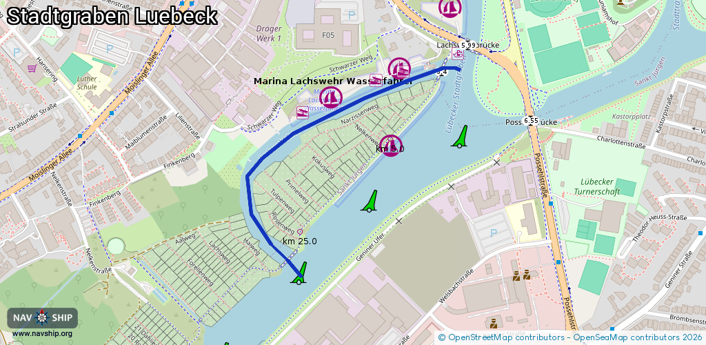
Route:
Please wait, loading route graphic...
Request waterway overview map with symbol legend here (Link).
Information about data associated with this body of water (7 available):
Data by OpenSeaMap (c) OSM contributors, www.openseamap.org
| # | Kind | Coordinates | Name | Information |
|---|---|---|---|---|
| 1 | Marina | 53.856,10.67454 | 2015-10-23T17:34:09Z | Marina Lachswehr Wasserfahrer Tel.0451/83490 (17:00- 19:00 Uhr) Austattung: Waschmaschine und Trockner, Dusche/WC, Fäkalienentsorgung, Slipanlage. Strom- und Wasseranschluss am Steg.Überdachter Grillplatz [email protected] +49 170 5247148 http://www.lwl-luebeck.de/ |
| 2 | Marina | 53.8566,10.67689 | 2020-10-23T21:43:48Z | Lübecker Motorboot-Club (LMC) |
| 3 | Bridge | 53.85304,10.6735 | Unknown | Clearance height: 2024-12-17T23:30:22Z m Maximum passage width: 2.40 m fixed |
| 4 | Bridge | 53.85649,10.67825 | Unknown | Clearance height: 2024-12-17T23:30:22Z m Maximum passage width: 3.40 m fixed |
| 5 | Slipway | 53.85575,10.67392 | small_craft_facility | 2019-08-22T19:12:17Z |
| 6 | Slipway | 53.85634,10.6762 | small_craft_facility | 2019-08-22T19:12:17Z |
| 7 | Slipway | 53.85649,10.67705 | small_craft_facility | 2019-08-22T19:12:17Z |