Waterway information

Kind:
Inland
Driving areas:
🌊 Baltic Sea🇩🇪 Germany
Length:
7.7 km¹
¹River kilometers or bank length recorded in NavShip, including river arms and harbor entrances.
Availability:
Completely recorded
Recent Update: 02.09.2025²
² This date indicates when an adjustment last took place in the course of the body of water
Recorded:
Locks: 0
Harbours / marinas: 3
Bridges: 1
Berths: 6
Slipways: 2
Fuelstations: 1
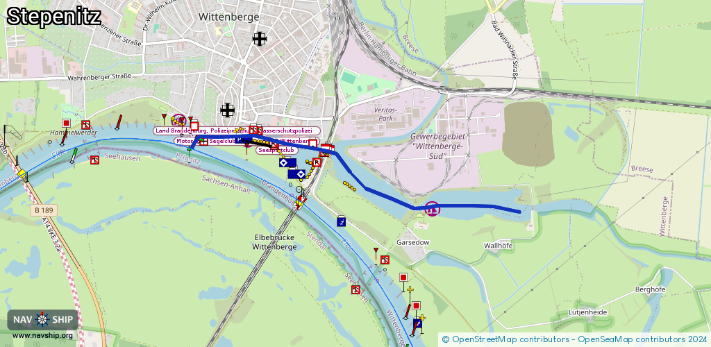
Route:
Please wait, loading route graphic...
Request waterway overview map with symbol legend here (Link).
Information about data associated with this body of water (13 available):
Data by OpenSeaMap (c) OSM contributors, www.openseamap.org
| # | Kind | Coordinates | Name | Information |
|---|---|---|---|---|
| 1 | Marina | 52.98402,11.77585 | 2017-10-04T19:33:17Z | Wassersportverein Wittenberge +49 3877 403096 http://wsv-wittenberge.de/ |
| 2 | Marina | 52.98915,11.75304 | 2013-01-18T14:07:56Z | Sportbootanleger Nedwighafen |
| 3 | Marina | 53.9059,10.96872 | 2025-02-01T23:39:14Z | Dassower Wassersport Verein |
| 4 | Bridge | 52.98852,11.76291 | Unknown | Clearance height: 2015-05-18T13:50:50Z m Movable bridge (e.g. lifting bridge or drawbridge) fixed |
| 5 | Slipway | 52.98387,11.77506 | small_craft_facility | 2013-04-11T11:36:02Z |
| 6 | Slipway | 52.9902,11.74651 | small_craft_facility | 2012-12-21T14:05:33Z |
| 7 | Berth | 52.9889,11.75636 | 2014-04-09T12:44:50Z | |
| 8 | Berth | 52.98839,11.75665 | 2014-04-09T12:44:54Z | Seesportclub |
| 9 | Berth | 52.98965,11.75062 | 2014-04-09T12:44:49Z | Fahrgastschiffsliegestelle |
| 10 | Berth | 52.9899,11.75161 | 2014-04-09T12:48:14Z | Land Brandenburg, Polizeipräsidium/Wasserschutzpolizei |
| 11 | Berth | 52.98906,11.75278 | 2014-04-09T12:44:50Z | Motor- und Segelclub Neptun e.V., Wittenberge |
| 12 | Berth | 52.98996,11.74737 | 2014-04-09T12:44:49Z | KD Deutsche Flußkreuzfahrt |
| 13 | Fuel station | 52.99039,11.74598 | 2025-02-09T13:02:20Z | Schiffstankstelle |