Waterway information

Kind:
Lower
Driving areas:
🇳🇱 Netherlands
Length:
3.3 km¹
¹River kilometers or bank length recorded in NavShip, including river arms and harbor entrances.
Availability:
Completely recorded
Recent Update: 13.01.2023²
² This date indicates when an adjustment last took place in the course of the body of water
Recorded:
Locks: 0
Harbours / marinas: 0
Bridges: 6
Berths: 0
Slipways: 0
Fuelstations: 0
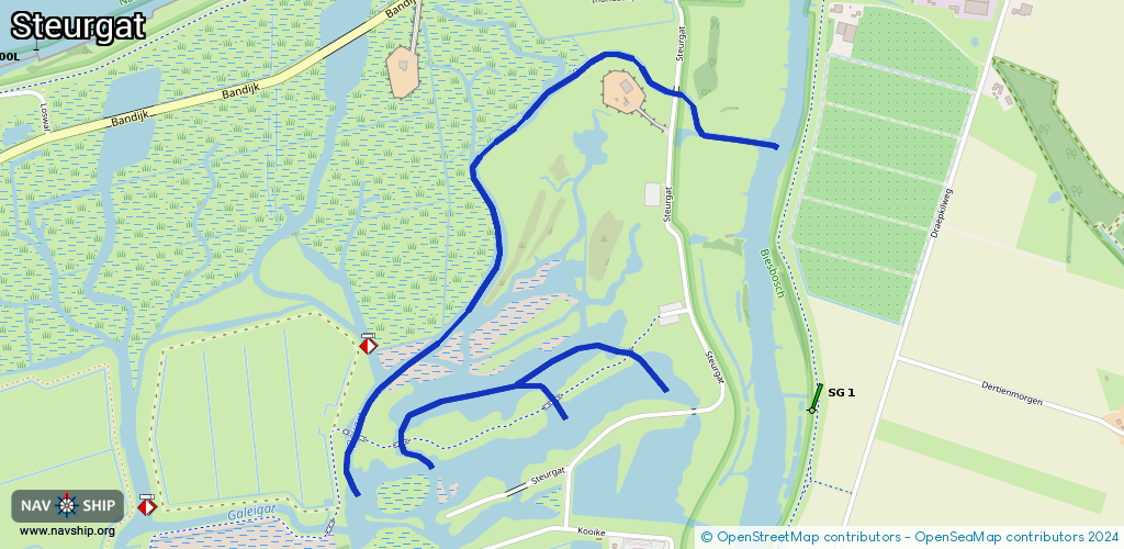
Route:
Please wait, loading route graphic...
Request waterway overview map with symbol legend here (Link).
Information about data associated with this body of water (6 available):
Data by OpenSeaMap (c) OSM contributors, www.openseamap.org
| # | Kind | Coordinates | Name | Information |
|---|---|---|---|---|
| 1 | Bridge | 51.78976,4.87001 | Unknown | Clearance height: 2018-10-06T19:42:40Z m Maximum passage width: 0.2 m fixed |
| 2 | Bridge | 51.78777,4.85918 | Unknown | Clearance height: 2018-10-06T19:42:39Z m Maximum passage width: 1 m fixed |
| 3 | Bridge | 51.79604,4.87178 | Unknown | Clearance height: 2018-10-06T19:42:40Z m Maximum passage width: 1 m fixed |
| 4 | Bridge | 51.78859,4.86705 | Unknown | Clearance height: 2018-10-06T19:42:39Z m Maximum passage width: 0.2 m fixed |
| 5 | Bridge | 51.78758,4.86105 | Unknown | Clearance height: 2018-10-06T19:42:39Z m Maximum passage width: 0.2 m fixed |
| 6 | Bridge | 51.78758,4.86108 | Unknown | Clearance height: 2018-10-14T14:23:01Z m Maximum passage width: 0.5 m fixed |