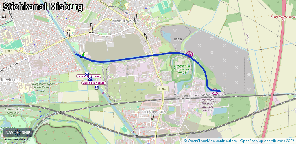
Waterway information

Kind:
Inland
Driving areas:
🇩🇪 Germany
Length:
3.4 km¹
¹River kilometers or bank length recorded in NavShip, including river arms and harbor entrances.
Availability:
Completely recorded
Recent Update: 09.04.2025²
² This date indicates when an adjustment last took place in the course of the body of water
Recorded:
Locks: 0
Harbours / marinas: 2
Bridges: 3
Berths: 0
Slipways: 0
Fuelstations: 0
Route:
Please wait, loading route graphic...
Request waterway overview map with symbol legend here (Link).
Information about data associated with this body of water (5 available):
Data by OpenSeaMap (c) OSM contributors, www.openseamap.org
| # | Kind | Coordinates | Name | Information |
|---|---|---|---|---|
| 1 | Marina | 52.37726,9.87951 | 2025-06-11T18:22:38Z | Hafen Heidelberg Materials AG Werk Hannover |
| 2 | Marina | 52.38399,9.8721 | 2025-12-26T10:27:07Z | Hannoverscher Motorboot Club von 1975 [email protected] +49 5119 585255 http://www.hmc-hannover.org/ http://www.hmc-hannover.org/fotos/11090013.jpg |
| 3 | Bridge | 52.38296,9.87336 | Unknown | Clearance height: 2013-11-28T11:03:38Z m Maximum passage width: 6.38 m fixed |
| 4 | Bridge | 52.38433,9.86809 | Unknown | Clearance height: 2013-11-28T11:03:38Z m fixed |
| 5 | Bridge | 52.38388,9.86081 | Unknown | Clearance height: 2013-11-28T11:03:38Z m Maximum passage width: 4.4 m fixed |