Waterway information

Kind:
Inland
Driving areas:
🇳🇴 Norway
Length:
11.9 km¹
¹River kilometers or bank length recorded in NavShip, including river arms and harbor entrances.
Availability:
Completely recorded
Recent Update: 10.02.2025²
² This date indicates when an adjustment last took place in the course of the body of water
Recorded:
Locks: 0
Harbours / marinas: 5
Bridges: 3
Berths: 0
Slipways: 3
Fuelstations: 0
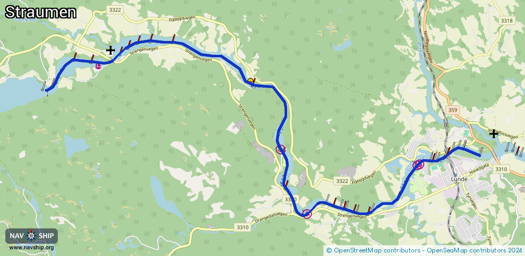
Route:
Please wait, loading route graphic...
Request waterway overview map with symbol legend here (Link).
Information about data associated with this body of water (11 available):
Data by OpenSeaMap (c) OSM contributors, www.openseamap.org
| # | Kind | Coordinates | Name | Information |
|---|---|---|---|---|
| 1 | Marina | 59.31775,8.9816 | 2023-05-10T08:28:56Z | Strengen brygge |
| 2 | Marina | 59.30324,9.04264 | 2023-05-10T08:28:56Z | Hogga sluser |
| 3 | Marina | 59.29221,9.05152 | 2023-05-10T08:28:56Z | Kjeldal sluse |
| 4 | Marina | 59.30049,9.08835 | 2023-05-10T08:28:56Z | Lunde sluse |
| 5 | Marina | 59.30072,9.08921 | 2023-05-10T08:28:56Z | Lunde |
| 6 | Bridge | 59.31849,8.98611 | Unknown | Clearance height: 2023-04-17T09:16:01Z m Movable bridge (e.g. lifting bridge or drawbridge) fixed |
| 7 | Bridge | 59.30235,9.09862 | Unknown | Clearance height: 2023-04-17T09:16:01Z m Movable bridge (e.g. lifting bridge or drawbridge) fixed |
| 8 | Bridge | 59.30253,9.09913 | Unknown | Clearance height: 2023-04-17T09:16:01Z m Movable bridge (e.g. lifting bridge or drawbridge) fixed |
| 9 | Slipway | 59.31853,8.9878 | small_craft_facility | 2023-05-09T14:36:59Z Strengen |
| 10 | Slipway | 59.31478,9.03032 | small_craft_facility | 2023-05-09T14:36:59Z Kåsa tømmeropptaksplass |
| 11 | Slipway | 59.30395,9.10133 | small_craft_facility | 2023-05-09T14:36:59Z Lunde |