Waterway information

Kind:
Inland
Driving areas:
🇦🇺 Australia
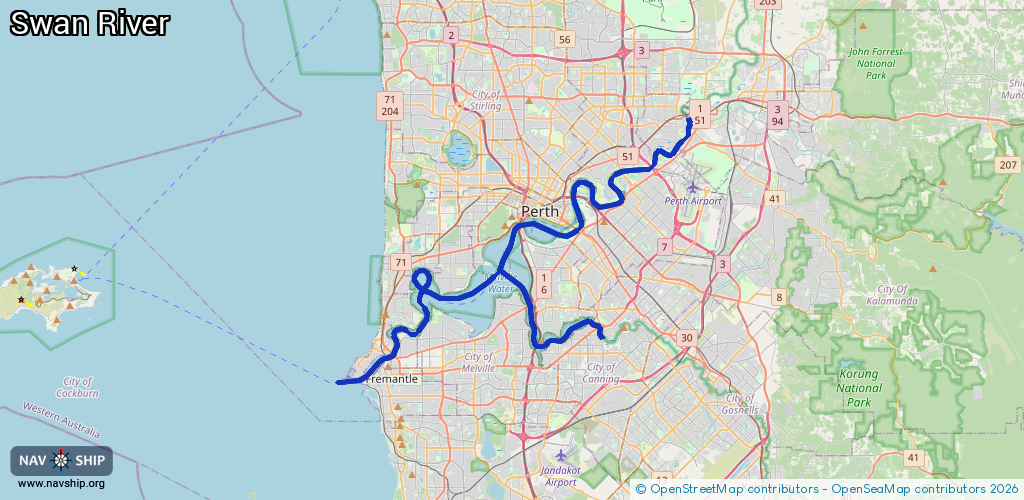
Length:
55.8 km¹
¹River kilometers or bank length recorded in NavShip, including river arms and harbor entrances.
Availability:
Completely recorded
Recent Update: 06.09.2024²
² This date indicates when an adjustment last took place in the course of the body of water
Recorded:
Locks: 0
Harbours / marinas: 12
Bridges: 0
Berths: 20
Slipways: 4
Fuelstations: 0
Route:
Please wait, loading route graphic...
Request waterway overview map with symbol legend here (Link).
Information about data associated with this body of water (36 available):
Data by OpenSeaMap (c) OSM contributors, www.openseamap.org
| # | Kind | Coordinates | Name | Information |
|---|
| 1 | Marina | -31.98886,115.77869 | 2024-05-09T13:58:30Z | Claremont Yacht Club |
| 2 | Marina | -31.93654,115.89113 | 2024-05-11T14:42:14Z | Maylands Yacht Club
+61 434 458 723
https://www.maylandsyachtclub.org.au/ |
| 3 | Marina | -31.98526,115.82433 | 2013-12-02T06:32:41Z | |
| 4 | Marina | -31.98496,115.82431 | 2025-07-13T11:49:06Z | Royal Perth Yacht Club
https://www.rpyc.com.au/ |
| 5 | Marina | -31.99447,115.81279 | 2025-05-20T23:22:23Z | Nedlands Yacht Club |
| 6 | Marina | -32.00105,115.80964 | 2025-05-20T23:22:23Z | Perth Flying Squadron Yacht Club
+61 8 9386 6437
https://www.pfsyc.com.au/ |
| 7 | Marina | -32.00236,115.7734 | 2025-03-05T22:00:38Z | Keane's Point
+61 8 9286 8200
https://www.rfbyc.asn.au/ |
| 8 | Marina | -32.02862,115.77383 | 2024-05-19T13:13:31Z | East Fremantle Yacht Club |
| 9 | Marina | -32.02581,115.76585 | 2020-07-27T13:00:24Z | |
| 10 | Marina | -32.02623,115.76262 | 2020-07-27T13:00:24Z | |
| 11 | Marina | -32.04931,115.74272 | 2025-07-28T19:52:36Z | Fremantle Inner Harbour |
| 12 | Marina | -32.00299,115.84687 | 2020-11-24T04:40:05Z | South of Perth Yacht Club |
| 13 | Slipway | -32.01314,115.79207 | small_craft_facility | 2023-10-06T12:51:40Z
By car,Shallow ramp |
| 14 | Slipway | -32.01236,115.78863 | small_craft_facility | 2014-04-12T12:49:03Z
№ 0916
by car |
| 15 | Slipway | -32.05524,115.73887 | small_craft_facility | 2025-04-14T04:13:22Z
cable winch |
| 16 | Slipway | -32.055,115.73882 | small_craft_facility | 2025-04-14T04:13:22Z
cable winch |
| 17 | Berth | -32.04198,115.75313 | 2024-08-21T23:35:12Z | Small Craft Pens |
| 18 | Berth | -32.04249,115.75245 | 2024-08-21T23:35:12Z | Berth J |
| 19 | Berth | -32.04001,115.75199 | 2024-08-21T23:35:12Z | Berth 12 |
| 20 | Berth | -32.04359,115.75111 | 2024-08-21T23:35:12Z | Berth I |
| 21 | Berth | -32.04435,115.75035 | 2024-08-21T23:35:12Z | Berth H |
| 22 | Berth | -32.04521,115.7494 | 2024-08-21T23:35:12Z | Berth G |
| 23 | Berth | -32.04164,115.74747 | 2024-08-21T23:35:12Z | Berth CT4 |
| 24 | Berth | -32.04028,115.74969 | 2024-08-21T23:35:12Z | Berth 11 |
| 25 | Berth | -32.04774,115.74687 | 2024-08-21T23:35:12Z | Berth F |
| 26 | Berth | -32.04956,115.74506 | 2024-08-21T23:35:12Z | Berth E |
| 27 | Berth | -32.04695,115.74214 | 2024-08-21T23:35:12Z | Berth CT2 |
| 28 | Berth | -32.04432,115.74489 | 2024-08-21T23:35:12Z | Berth CT3 |
| 29 | Berth | -32.05082,115.74389 | 2024-08-21T23:35:12Z | Berth D |
| 30 | Berth | -32.05193,115.74274 | 2024-08-21T23:35:12Z | Berth C |
| 31 | Berth | -32.05265,115.74189 | 2024-08-21T23:35:12Z | O'Connor Landing |
| 32 | Berth | -32.05323,115.74104 | 2024-08-21T23:35:12Z | Berth B |
| 33 | Berth | -32.05365,115.74042 | 2025-07-25T06:10:23Z | Corkhill Landing |
| 34 | Berth | -32.05089,115.73959 | 2024-08-21T23:35:12Z | Berth 2 |
| 35 | Berth | -32.05231,115.7379 | 2024-08-21T23:35:12Z | Berth 1 |
| 36 | Berth | -32.04838,115.74071 | 2024-08-21T23:35:12Z | Berth CT1 |