Waterway information

Kind:
Inland
Driving areas:
🌊 Atlantic Ocean🇫🇷 France
Length:
21.1 km¹
¹River kilometers or bank length recorded in NavShip, including river arms and harbor entrances.
Availability:
Completely recorded
Recent Update: 17.07.2025²
² This date indicates when an adjustment last took place in the course of the body of water
Recorded:
Locks: 1
Harbours / marinas: 3
Bridges: 0
Berths: 0
Slipways: 2
Fuelstations: 0
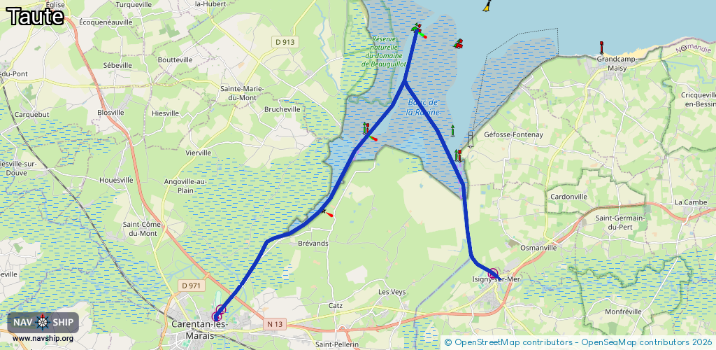
Route:
Please wait, loading route graphic...
Request waterway overview map with symbol legend here (Link).
Information about data associated with this body of water (6 available):
Data by OpenSeaMap (c) OSM contributors, www.openseamap.org
| # | Kind | Coordinates | Name | Information |
|---|---|---|---|---|
| 1 | Marina | 49.30729,-1.23803 | 2022-05-19T13:06:37Z | Capitainerie |
| 2 | Marina | 49.30752,-1.23825 | 2021-03-03T21:16:42Z | Port de Plaisance [email protected] +33233422444 |
| 3 | Marina | 49.32107,-1.10238 | 2024-06-16T10:44:07Z | Port de plaisance d'Isigny-sur-Mer +33 2 31 51 24 01 https://www.isigny-sur-mer.fr/vivre-a-isigny-sur-mer/port.html |
| 4 | Slipway | 49.31931,-1.09875 | small_craft_facility | 2024-06-14T06:54:37Z |
| 5 | Slipway | 49.321,-1.10162 | small_craft_facility | 2024-06-05T10:38:14Z |
| 6 | Lock | 49.3173,-1.22668 | Unknown |