Waterway information

Kind:
Inland
Driving areas:
🇮🇹 Italy🌊 Sea Mediterranean
Length:
6.8 km¹
¹River kilometers or bank length recorded in NavShip, including river arms and harbor entrances.
Availability:
Completely recorded
Recent Update: 11.07.2024²
² This date indicates when an adjustment last took place in the course of the body of water
Recorded:
Locks: 0
Harbours / marinas: 3
Bridges: 0
Berths: 2
Slipways: 0
Fuelstations: 0
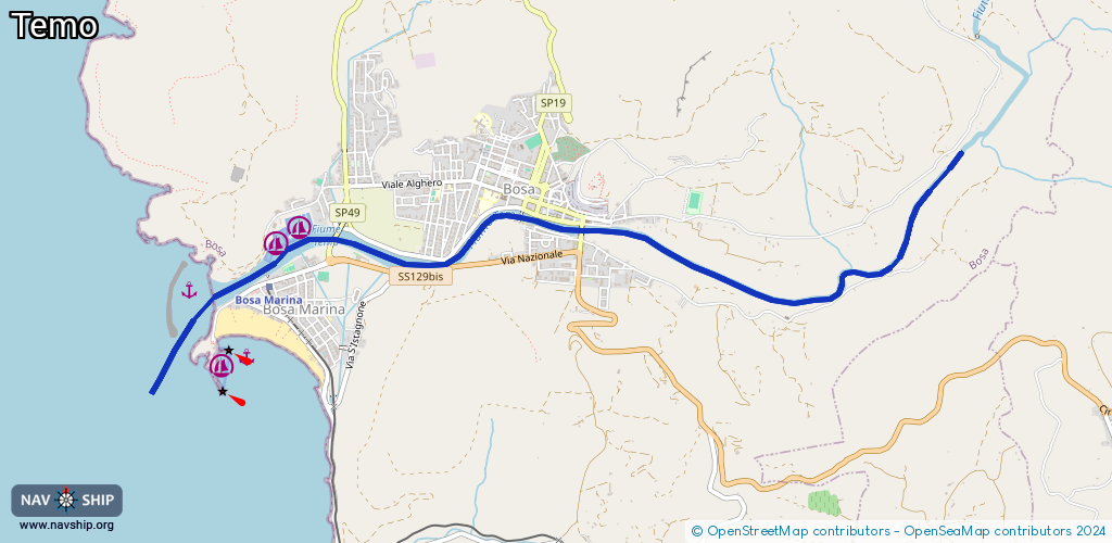
Route:
Please wait, loading route graphic...
Request waterway overview map with symbol legend here (Link).
Information about data associated with this body of water (5 available):
Data by OpenSeaMap (c) OSM contributors, www.openseamap.org
| # | Kind | Coordinates | Name | Information |
|---|---|---|---|---|
| 1 | Marina | 40.2949,8.48115 | 2024-07-04T11:44:52Z | Porto di Bosa http://www.portodibosa.com/ |
| 2 | Marina | 40.29394,8.47937 | 2024-07-04T11:44:52Z | Nautica Pinna http://www.nauticapinna.it |
| 3 | Marina | 40.28654,8.47488 | 2024-07-04T11:36:59Z | Porticciolo di Renato Pirisi http://www.porticciolodibosamarina.com |
| 4 | Berth | 40.29085,8.47254 | 2017-02-20T20:11:19Z | |
| 5 | Berth | 40.28681,8.47708 | 2017-02-20T20:08:31Z |