Waterway information

Kind:
Inland
Driving areas:
🇺🇸 United States of America
Length:
1099.8 km¹, 1049 km official total length
¹River kilometers or bank length recorded in NavShip, including river arms and harbor entrances.
Availability:
Completely recorded
Recent Update: 12.02.2026²
² This date indicates when an adjustment last took place in the course of the body of water
Recorded:
Locks: 9
Harbours / marinas: 31
Bridges: 0
Berths: 0
Slipways: 0
Fuelstations: 4
Useful information:
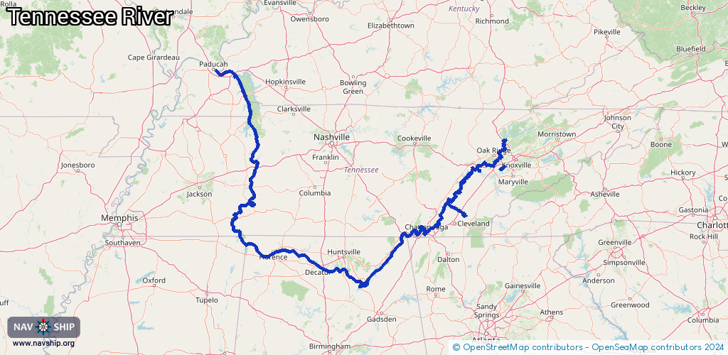
The Tennessee River is a tributary of the Ohio River, which flows through the US states of Tennessee, Kentucky, Alabama and Mississippi.
The Tennessee River makes its way through fertile valleys and flows at the foot of green mountain ridges.
It is formed by the confluence of the Holston River and the French Broad River near Knoxville. From there it flows to Chattanooga, through northern Alabama and then back to Tennessee.
The river is one of the most important waterways in the south-east of the United States. The river probably got its name from the Cherekee Indian village "Tanasi" on the Little Tennessee River.
Translated with DeepL.com (free version)
Route:
Please wait, loading route graphic...
Request waterway overview map with symbol legend here (Link).
Information about data associated with this body of water (44 available):
Data by OpenSeaMap (c) OSM contributors, www.openseamap.org
| # | Kind | Coordinates | Name | Information |
|---|
| 1 | Marina | 35.73623,-84.66841 | 2023-12-05T14:16:35Z | Blue Springs Marina |
| 2 | Marina | 34.39687,-86.27944 | 2022-08-31T00:23:39Z | |
| 3 | Marina | 34.38575,-86.2747 | 2022-08-31T00:18:58Z | |
| 4 | Marina | 35.98599,-84.19139 | 2026-02-17T07:26:45Z | Melton Hill Marina |
| 5 | Marina | 35.40926,-85.0092 | 2022-01-19T23:32:46Z | |
| 6 | Marina | 35.14123,-85.17504 | 2025-01-03T20:16:05Z | Big Ridge Yacht Club |
| 7 | Marina | 35.05405,-85.32162 | 2020-07-27T18:39:11Z | Cameron Harbor Marina
Transient slips
[email protected] |
| 8 | Marina | 35.12459,-85.14513 | 2025-09-29T16:49:24Z | Chattanooga Yacht Club |
| 9 | Marina | 35.13764,-85.12371 | 2024-04-09T18:48:13Z | Island Cove Marina |
| 10 | Marina | 34.88376,-88.10514 | 2025-11-23T13:37:16Z | Eastport Marina
+1-662-423-6972
https://epmarina.com/ |
| 11 | Marina | 34.88397,-88.10574 | 2025-11-10T19:14:27Z | Eastport Marina
+1 662-423-6972
https://epmarina.com/ |
| 12 | Marina | 35.8396,-84.16993 | 2024-12-21T14:51:23Z | |
| 13 | Marina | 35.83934,-84.16977 | 2024-12-21T14:51:23Z | |
| 14 | Marina | 35.75101,-84.65885 | 2024-04-11T13:16:07Z | |
| 15 | Marina | 36.99209,-88.28569 | 2022-05-23T05:52:10Z | |
| 16 | Marina | 35.16866,-85.12196 | 2024-10-15T15:25:29Z | Harrison Bay State Park Marina |
| 17 | Marina | 35.72877,-84.72535 | 2023-05-08T23:44:34Z | Eden Marina |
| 18 | Marina | 34.3631,-86.3441 | 2022-08-21T16:36:20Z | |
| 19 | Marina | 37.00044,-88.24007 | 2022-05-23T05:56:09Z | |
| 20 | Marina | 35.87034,-84.60411 | 2024-02-29T21:46:50Z | Marina Store/Gas Station |
| 21 | Marina | 35.87018,-84.6039 | 2023-12-05T16:18:24Z | Caney Creek Marina |
| 22 | Marina | 35.05271,-88.23633 | 2025-12-29T01:30:08Z | |
| 23 | Marina | 35.05292,-88.2357 | 2025-12-29T01:30:08Z | |
| 24 | Marina | 35.05324,-88.23523 | 2025-12-29T01:30:08Z | |
| 25 | Marina | 35.05341,-88.23487 | 2025-12-29T01:30:08Z | |
| 26 | Marina | 35.05346,-88.23444 | 2025-12-29T01:30:08Z | |
| 27 | Marina | 35.0536,-88.23396 | 2025-12-29T01:30:08Z | |
| 28 | Marina | 35.8485,-84.15243 | 2025-07-11T15:27:10Z | |
| 29 | Marina | 35.84867,-84.15117 | 2021-08-31T20:50:02Z | |
| 30 | Marina | 34.41151,-86.26746 | 2022-08-31T00:31:22Z | |
| 31 | Marina | 34.36142,-86.29013 | 2025-06-12T22:52:06Z | Guntersville City Harbor |
| 32 | Fuel station | 35.10872,-85.21624 | 2025-01-21T19:07:14Z | |
| 33 | Fuel station | 35.87021,-84.60418 | 2024-02-29T21:46:50Z | |
| 34 | Fuel station | 35.87018,-84.60419 | 2024-02-29T21:46:50Z | |
| 35 | Fuel station | 35.87015,-84.60422 | 2024-02-29T21:46:50Z | |
| 36 | Lock | 35.88635,-84.30072 | Unknown | |
| 37 | Lock | 35.62162,-84.77935 | Unknown | |
| 38 | Lock | 35.10615,-85.22889 | Unknown | |
| 39 | Lock | 35.00505,-85.62081 | Unknown | |
| 40 | Lock | 34.42623,-86.39195 | Unknown | |
| 41 | Lock | 34.81361,-87.38346 | Unknown | |
| 42 | Lock | 34.80437,-87.62818 | Unknown | |
| 43 | Lock | 35.06503,-88.25025 | Unknown | |
| 44 | Lock | 37.01461,-88.26482 | Unknown | |