Waterway information

Kind:
Inland
Driving areas:
Other areas
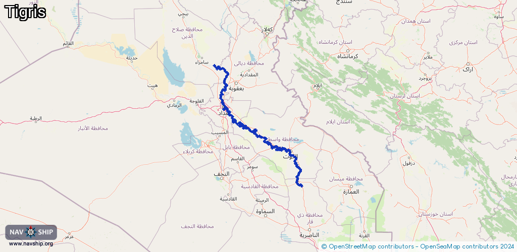
Length:
573.8 km¹
¹River kilometers or bank length recorded in NavShip, including river arms and harbor entrances.
Availability:
Completely recorded
Recent Update: 23.01.2024²
² This date indicates when an adjustment last took place in the course of the body of water
Recorded:
Locks: 2
Harbours / marinas: 16
Bridges: 0
Berths: 0
Slipways: 0
Fuelstations: 0
Route:
Please wait, loading route graphic...
Request waterway overview map with symbol legend here (Link).
Information about data associated with this body of water (16 available):
Data by OpenSeaMap (c) OSM contributors, www.openseamap.org
| # | Kind | Coordinates | Name | Information |
|---|---|---|---|---|
| 1 | Marina | 33.27574,44.36619 | 2020-09-19T17:05:29Z | |
| 2 | Marina | 33.27529,44.36615 | 2020-09-19T17:05:29Z | |
| 3 | Marina | 33.28271,44.37441 | 2023-07-10T11:27:28Z | |
| 4 | Marina | 33.28168,44.37362 | 2021-06-20T23:38:28Z | |
| 5 | Marina | 33.28527,44.3774 | 2021-06-20T23:38:28Z | |
| 6 | Marina | 33.28421,44.37618 | 2021-06-20T23:38:28Z | |
| 7 | Marina | 33.28645,44.37865 | 2021-06-20T23:38:28Z | |
| 8 | Marina | 33.28584,44.37807 | 2021-06-20T23:38:28Z | |
| 9 | Marina | 33.29112,44.38614 | 2021-06-20T23:38:28Z | |
| 10 | Marina | 33.2931,44.39204 | 2021-06-20T23:38:28Z | |
| 11 | Marina | 33.29269,44.39103 | 2021-06-20T23:38:28Z | |
| 12 | Marina | 33.29635,44.39735 | 2022-07-26T12:42:55Z | |
| 13 | Marina | 33.32817,44.39878 | 2023-05-12T17:10:25Z | |
| 14 | Marina | 33.32588,44.40115 | 2021-06-20T23:38:28Z | |
| 15 | Marina | 33.33464,44.39401 | 2023-05-12T17:10:25Z | |
| 16 | Marina | 33.33932,44.38749 | 2023-07-10T11:27:28Z | مرسى المتنبي |
| 16 | Marina | 33.33932,44.38749 | 2023-07-10T11:27:28Z | مرسى المتنبي |
| 16 | Marina | 33.33932,44.38749 | 2023-07-10T11:27:28Z | مرسى المتنبي |