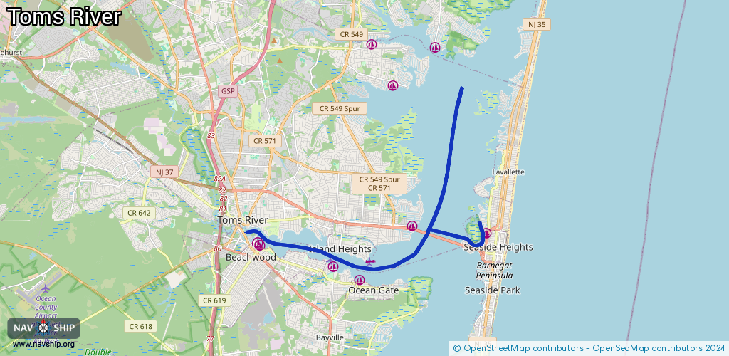
Waterway information

Kind:
Inland
Driving areas:
🌊 Atlantic Ocean🇺🇸 United States of America
Length:
20.3 km¹
¹River kilometers or bank length recorded in NavShip, including river arms and harbor entrances.
Availability:
Completely recorded
Recent Update: 28.05.2025²
² This date indicates when an adjustment last took place in the course of the body of water
Recorded:
Locks: 0
Harbours / marinas: 9
Bridges: 0
Berths: 0
Slipways: 0
Fuelstations: 1
Route:
Please wait, loading route graphic...
Request waterway overview map with symbol legend here (Link).
Information about data associated with this body of water (10 available):
Data by OpenSeaMap (c) OSM contributors, www.openseamap.org
| # | Kind | Coordinates | Name | Information |
|---|---|---|---|---|
| 1 | Marina | 39.94563,-74.19243 | 2025-05-21T03:37:24Z | |
| 2 | Marina | 39.94982,-74.19347 | 2024-11-27T01:05:08Z | |
| 3 | Marina | 39.94425,-74.18979 | 2025-01-01T20:30:03Z | Beachwood Yacht Club |
| 4 | Marina | 39.94313,-74.18852 | 2025-03-19T17:18:02Z | Riverfront Marina |
| 5 | Marina | 39.93531,-74.15293 | 2025-10-31T23:19:17Z | |
| 6 | Marina | 39.93036,-74.14043 | 2024-07-03T19:36:26Z | |
| 7 | Marina | 39.95038,-74.11516 | 2021-08-27T07:45:29Z | Pier 1 Marina |
| 8 | Marina | 39.95817,-74.12387 | 2025-05-16T06:29:14Z | |
| 9 | Marina | 39.94776,-74.07945 | 2020-05-19T21:33:26Z | Cranberry Inlet Marina |
| 10 | Fuel station | 39.93549,-74.15201 | 2025-10-31T23:19:17Z |