Waterway information

Kind:
Inland
Driving areas:
🇩🇪 Germany
Length:
44 km¹
¹River kilometers or bank length recorded in NavShip, including river arms and harbor entrances.
Availability:
Completely recorded
Recent Update: 04.07.2024²
² This date indicates when an adjustment last took place in the course of the body of water
Recorded:
Locks: 0
Harbours / marinas: 2
Bridges: 8
Berths: 0
Slipways: 1
Fuelstations: 0
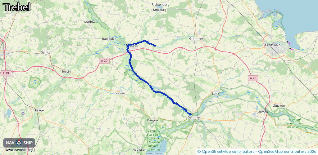
Route:
Please wait, loading route graphic...
Request waterway overview map with symbol legend here (Link).
Information about data associated with this body of water (11 available):
Data by OpenSeaMap (c) OSM contributors, www.openseamap.org
| # | Kind | Coordinates | Name | Information |
|---|---|---|---|---|
| 1 | Marina | 53.996,12.82925 | 2012-12-17T09:51:47Z | Wasserwanderrastplatz Nehringen +49 38334 80311 |
| 2 | Marina | 53.928,12.99548 | 2012-12-17T09:51:47Z | Wasserwanderrastplatz |
| 3 | Bridge | 54.10103,12.78386 | Unknown | Clearance height: 2012-12-17T09:51:47Z m fixed |
| 4 | Bridge | 54.09865,12.76713 | Unknown | Clearance height: 2013-12-15T16:44:08Z m fixed |
| 5 | Bridge | 54.09655,12.75172 | Unknown | Clearance height: 2023-05-16T12:20:03Z m fixed |
| 6 | Bridge | 54.07903,12.74038 | Unknown | Clearance height: 2012-12-17T09:51:56Z m fixed |
| 7 | Bridge | 54.07738,12.74096 | Unknown | Clearance height: 2016-04-19T09:26:37Z m fixed |
| 8 | Bridge | 54.03252,12.7606 | Unknown | Clearance height: 2012-12-17T09:51:54Z m fixed |
| 9 | Bridge | 53.99754,12.82575 | Unknown | Clearance height: 2023-09-13T17:29:11Z m Movable bridge (e.g. lifting bridge or drawbridge) opening https://commons.wikimedia.org/wiki/File:Nehringen,_Klappbr%C3%BCcke_%C3%BCber_die_Trebel_(2009-09-20).JPG |
| 10 | Bridge | 53.92779,12.99488 | Unknown | Clearance height: 2012-12-17T09:51:56Z m Maximum passage width: 3.9 m fixed |
| 11 | Slipway | 53.9277,12.99435 | small_craft_facility | 2013-05-12T15:22:03Z by car |