Waterway information

Kind:
Sea
Driving areas:
🌊 Baltic Sea🇩🇪 Germany
Length:
4.7 km¹
¹River kilometers or bank length recorded in NavShip, including river arms and harbor entrances.
Availability:
Completely recorded
Recent Update: 04.05.2023²
² This date indicates when an adjustment last took place in the course of the body of water
Recorded:
Locks: 0
Harbours / marinas: 4
Bridges: 1
Berths: 0
Slipways: 1
Fuelstations: 1
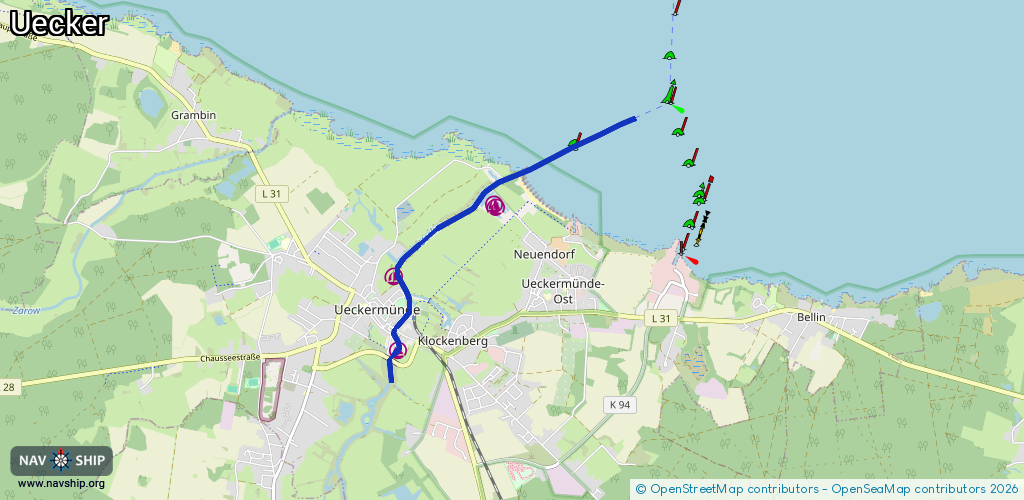
Route:
Please wait, loading route graphic...
Request waterway overview map with symbol legend here (Link).
Information about data associated with this body of water (7 available):
Data by OpenSeaMap (c) OSM contributors, www.openseamap.org
| # | Kind | Coordinates | Name | Information |
|---|---|---|---|---|
| 1 | Marina | 53.74806,14.06576 | 2025-08-08T11:55:43Z | |
| 2 | Marina | 53.74785,14.06562 | 2025-01-29T20:05:00Z | Lagunenstadt Ueckermünde [email protected] +49 39771 5300 https://lagunenstadt-ueckermuende.de/ http://www.lagunenstadt.de/wp-content/uploads/2012/03/Luft1_resized.jpg |
| 3 | Marina | 53.74042,14.04871 | 2023-08-14T16:04:35Z | Seesportclub Vorpommern e.V. http://www.ssc-vorpommern.de/ |
| 4 | Marina | 53.73291,14.04935 | 2023-01-13T20:04:02Z | |
| 5 | Bridge | 53.73507,14.0489 | Unknown | Clearance height: 2015-08-17T12:59:52Z m Maximum passage width: 1.50 m Movable bridge (e.g. lifting bridge or drawbridge) bascule 08:00-08:15, 10:00-10:15, 13:00-13:15, 15:00-15:15, 19:00-19:15, Sa, Su 17:00-17:15 || Sonderöffnungen sind gegen eine Zahlung von 15€ individuell mit dem Hafenmeister abzusprechen |
| 6 | Slipway | 53.74625,14.06732 | small_craft_facility | 2013-01-10T17:23:47Z |
| 7 | Fuel station | 53.74675,14.06676 | 2022-10-04T11:57:29Z | tägl 08.00-18.00 Uhr |