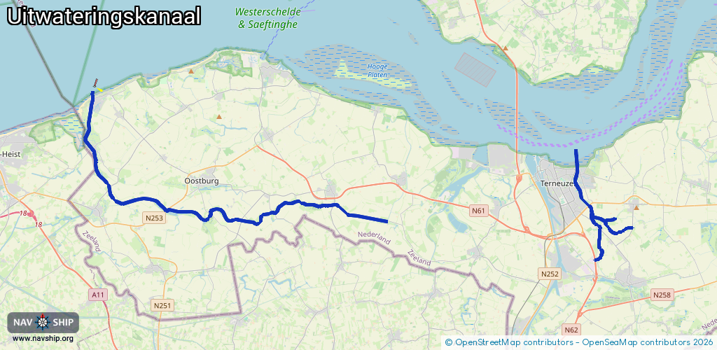
Waterway information

Kind:
Inland
Driving areas:
🇧🇪 Belgium🇳🇱 Netherlands🌊 North Sea
Length:
42.7 km¹
¹River kilometers or bank length recorded in NavShip, including river arms and harbor entrances.
Availability:
Completely recorded
Recent Update: 29.06.2023²
² This date indicates when an adjustment last took place in the course of the body of water
Recorded:
Locks: 0
Harbours / marinas: 2
Bridges: 2
Berths: 0
Slipways: 3
Fuelstations: 0
Route:
Please wait, loading route graphic...
Request waterway overview map with symbol legend here (Link).
Information about data associated with this body of water (7 available):
Data by OpenSeaMap (c) OSM contributors, www.openseamap.org
| # | Kind | Coordinates | Name | Information |
|---|---|---|---|---|
| 1 | Marina | 51.37917,3.38188 | 2025-01-03T00:05:02Z | Jachthaven Cadzand [email protected] +31 6 11410975 https://rycb.be/jachthavens/cadzand/ |
| 2 | Marina | 51.32808,3.8538 | 2025-01-03T21:59:55Z | Noordelijke Jachthaven |
| 3 | Bridge | 51.37775,3.3824 | Unknown | Clearance height: 2021-01-16T10:24:14Z m Maximum passage width: 1 m fixed |
| 4 | Bridge | 51.30495,3.87135 | Unknown | Clearance height: 2020-10-31T19:13:50Z m fixed |
| 5 | Slipway | 51.37843,3.3803 | small_craft_facility | 2025-04-22T11:59:38Z KNRM life boat launching |
| 6 | Slipway | 51.3798,3.38265 | small_craft_facility | 2021-01-16T10:24:14Z |
| 7 | Slipway | 51.32155,3.85823 | small_craft_facility | 2020-06-07T09:24:26Z |