Waterway information

Kind:
Inland
Driving areas:
🇩🇪 Germany
Length:
73.6 km¹
¹River kilometers or bank length recorded in NavShip, including river arms and harbor entrances.
Availability:
Completely recorded
Recent Update: 13.02.2025²
² This date indicates when an adjustment last took place in the course of the body of water
Recorded:
Locks: 4
Harbours / marinas: 0
Bridges: 8
Berths: 0
Slipways: 0
Fuelstations: 0
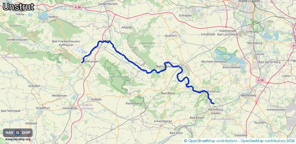
Route:
Please wait, loading route graphic...
Request waterway overview map with symbol legend here (Link).
Information about data associated with this body of water (12 available):
Data by OpenSeaMap (c) OSM contributors, www.openseamap.org
| # | Kind | Coordinates | Name | Information |
|---|---|---|---|---|
| 1 | Bridge | 51.27794,11.64975 | Unknown | Clearance height: 2015-05-18T12:18:06Z m fixed |
| 2 | Bridge | 51.24777,11.65722 | Unknown | Clearance height: 2015-05-18T12:18:06Z m fixed |
| 3 | Bridge | 51.2261,11.67783 | Unknown | Clearance height: 2020-11-24T08:50:07Z m fixed |
| 4 | Bridge | 51.22131,11.70226 | Unknown | Clearance height: 2015-05-18T12:18:10Z m fixed |
| 5 | Bridge | 51.21217,11.74606 | Unknown | Clearance height: 2015-05-18T12:18:06Z m fixed |
| 6 | Bridge | 51.20951,11.76899 | Unknown | Clearance height: 2015-05-18T12:18:06Z m fixed |
| 7 | Bridge | 51.20193,11.77462 | Unknown | Clearance height: 2015-05-18T12:18:10Z m fixed |
| 8 | Bridge | 51.18384,11.7874 | Unknown | Clearance height: 2015-05-18T12:18:05Z m fixed |
| 9 | Lock | 51.36172,11.28515 | Unknown | |
| 10 | Lock | 51.34775,11.32256 | Unknown | |
| 11 | Lock | 51.24864,11.63226 | Unknown | |
| 12 | Lock | 51.22604,11.67722 | Schleuse Laucha |