Waterway information

Kind:
Inland
Driving areas:
🇸🇪 Sweden
Length:
9.2 km¹
¹River kilometers or bank length recorded in NavShip, including river arms and harbor entrances.
Availability:
Completely recorded
Recent Update: 10.06.2025²
² This date indicates when an adjustment last took place in the course of the body of water
Recorded:
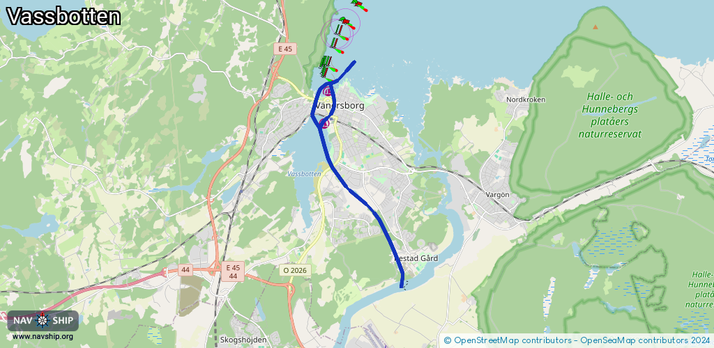
Locks: 1
Harbours / marinas: 1
Bridges: 3
Berths: 0
Slipways: 3
Fuelstations: 0
Route:
Please wait, loading route graphic...
Request waterway overview map with symbol legend here (Link).
Information about data associated with this body of water (7 available):
Data by OpenSeaMap (c) OSM contributors, www.openseamap.org
| # | Kind | Coordinates | Name | Information |
|---|---|---|---|---|
| 1 | Marina | 58.38347,12.33425 | 2024-08-28T19:27:31Z | |
| 2 | Bridge | 58.37862,12.3089 | 30 | Clearance height: 2022-06-13T21:33:28Z m Maximum passage width: 2 m Movable bridge (e.g. lifting bridge or drawbridge) opening |
| 3 | Bridge | 58.3824,12.31077 | 29.5 | Clearance height: 2022-06-10T20:36:10Z m Maximum passage width: 16.5 m fixed |
| 4 | Bridge | 58.36512,12.31888 | 30 | Clearance height: 2022-06-13T21:33:28Z m Maximum passage width: 4 m Movable bridge (e.g. lifting bridge or drawbridge) opening |
| 5 | Slipway | 58.38339,12.31488 | small_craft_facility | 2020-07-11T23:12:36Z |
| 6 | Slipway | 58.38321,12.33385 | Unknown | 2018-11-13T17:18:47Z |
| 7 | Slipway | 58.3777,12.31628 | small_craft_facility | 2020-07-11T23:12:36Z |
| 7 | Slipway | 58.3777,12.31628 | small_craft_facility | 2020-07-11T23:12:36Z |