Waterway information

Kind:
Sea
Driving areas:
🇩🇰 Denmark
Length:
56.3 km¹
¹River kilometers or bank length recorded in NavShip, including river arms and harbor entrances.
Availability:
Completely recorded
Recent Update: 02.08.2023²
² This date indicates when an adjustment last took place in the course of the body of water
Recorded:
Locks: 0
Harbours / marinas: 3
Bridges: 1
Berths: 0
Slipways: 4
Fuelstations: 0
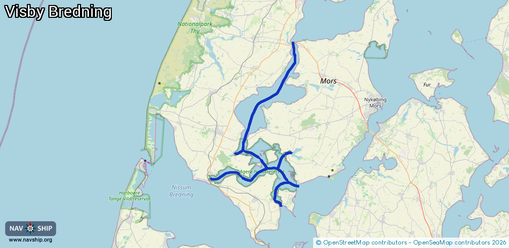
Route:
Please wait, loading route graphic...
Request waterway overview map with symbol legend here (Link).
Information about data associated with this body of water (8 available):
Data by OpenSeaMap (c) OSM contributors, www.openseamap.org
| # | Kind | Coordinates | Name | Information |
|---|---|---|---|---|
| 1 | Marina | 56.88283,8.62861 | 2021-05-04T10:46:20Z | Vilsund Havn +45 97 931266 http://vildsundhavn.skysite.dk/ |
| 2 | Marina | 56.71848,8.62671 | 2024-01-21T06:46:39Z | Tissinghus Havn |
| 3 | Marina | 56.71752,8.47399 | 2024-01-21T06:46:39Z | Doverodde Havn +45 20881137 |
| 4 | Bridge | 56.63932,8.59719 | Unknown | Clearance height: 2024-10-10T05:55:54Z m Maximum passage width: 1.8 m fixed |
| 5 | Slipway | 56.88145,8.62951 | Unknown | 2021-05-04T10:46:20Z |
| 6 | Slipway | 56.88236,8.62897 | small_craft_facility | 2021-05-04T10:46:20Z |
| 7 | Slipway | 56.64438,8.5813 | Unknown | 2013-05-06T13:44:51Z |
| 8 | Slipway | 56.71741,8.47263 | small_craft_facility | 2024-10-11T14:51:24Z |