Waterway information

Kind:
Inland
Driving areas:
🇳🇱 Netherlands🌊 North Sea
Length:
12.5 km¹
¹River kilometers or bank length recorded in NavShip, including river arms and harbor entrances.
Availability:
Completely recorded
Recent Update: 24.02.2026²
² This date indicates when an adjustment last took place in the course of the body of water
Recorded:
Locks: 0
Harbours / marinas: 6
Bridges: 2
Berths: 0
Slipways: 3
Fuelstations: 0
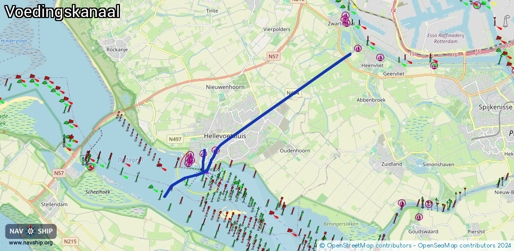
Route:
Please wait, loading route graphic...
Request waterway overview map with symbol legend here (Link).
Information about data associated with this body of water (11 available):
Data by OpenSeaMap (c) OSM contributors, www.openseamap.org
| # | Kind | Coordinates | Name | Information |
|---|---|---|---|---|
| 1 | Marina | 51.82643,4.12836 | 2024-05-21T06:00:34Z | |
| 2 | Marina | 51.82614,4.12034 | 2023-07-08T22:43:06Z | WSVHelius Watersport Vereniging Helius |
| 3 | Marina | 51.82424,4.11856 | 2022-11-10T10:36:03Z | WVH Watersport Vereniging Hellevoetsluis |
| 4 | Marina | 51.82372,4.12053 | 2023-08-10T23:16:24Z | Helius Haven Deze haven bestaat uit 3 verenigingen (WSV Haringvliet, WVH, WSV Helius) en de oost kant is van de gemeente. |
| 5 | Marina | 51.82217,4.11829 | 2023-07-08T23:46:26Z | WSV Haringvliet Watersport Vereniging Haringvliet |
| 6 | Marina | 51.82777,4.13721 | 2020-10-20T14:13:21Z | |
| 7 | Bridge | 51.82297,4.12859 | 14.9 | Clearance height: 2022-06-06T15:01:47Z m Maximum passage width: 2.4 m Movable bridge (e.g. lifting bridge or drawbridge) opening |
| 8 | Bridge | 51.82366,4.13412 | 13.9 | Clearance height: 2022-06-06T15:01:48Z m Maximum passage width: 1.9 m Movable bridge (e.g. lifting bridge or drawbridge) opening |
| 9 | Slipway | 51.82691,4.12172 | small_craft_facility | 2023-07-08T22:36:27Z |
| 10 | Slipway | 51.82484,4.11895 | small_craft_facility | 2023-07-08T23:22:09Z |
| 11 | Slipway | 51.82203,4.11771 | small_craft_facility | 2023-07-14T21:23:51Z |