Waterway information

Kind:
Inland
Driving areas:
🇳🇱 Netherlands
Length:
10.2 km¹
¹River kilometers or bank length recorded in NavShip, including river arms and harbor entrances.
Availability:
Completely recorded
Recent Update: 11.10.2024²
² This date indicates when an adjustment last took place in the course of the body of water
Recorded:
Locks: 0
Harbours / marinas: 4
Bridges: 4
Berths: 0
Slipways: 1
Fuelstations: 0
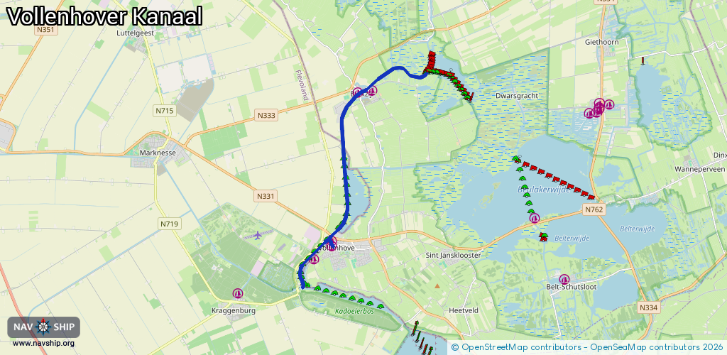
Route:
Please wait, loading route graphic...
Request waterway overview map with symbol legend here (Link).
Information about data associated with this body of water (9 available):
Data by OpenSeaMap (c) OSM contributors, www.openseamap.org
| # | Kind | Coordinates | Name | Information |
|---|---|---|---|---|
| 1 | Marina | 52.68258,5.94669 | 2020-08-03T20:27:48Z | Passantenhaven Vollenhove +31 6 20658979 http://havensweerribbenwieden.nl/vollenhove/ |
| 2 | Marina | 52.67731,5.93835 | 2025-04-17T10:14:08Z | |
| 3 | Marina | 52.72611,5.95927 | 2025-08-25T17:57:11Z | Haven de Kolk |
| 4 | Marina | 52.72664,5.96619 | 2025-08-25T17:57:11Z | |
| 5 | Bridge | 52.68178,5.94636 | 5.75 | Clearance height: 2017-05-31T16:05:43Z m Maximum passage width: 2 m Movable bridge (e.g. lifting bridge or drawbridge) opening |
| 6 | Bridge | 52.68424,5.94641 | 7 | Clearance height: 2024-06-21T11:15:41Z m Maximum passage width: 3 m Movable bridge (e.g. lifting bridge or drawbridge) opening BB H28 W72 |
| 7 | Bridge | 52.72646,5.96126 | 7 | Clearance height: 2022-06-06T07:07:28Z m Maximum passage width: 1 m Movable bridge (e.g. lifting bridge or drawbridge) opening |
| 8 | Bridge | 52.72637,5.96246 | Unknown | Clearance height: 2020-10-02T18:17:38Z m |
| 9 | Slipway | 52.66999,5.93184 | small_craft_facility | 2019-09-22T09:41:02Z |