Waterway information

Kind:
Inland
Driving areas:
🇩🇪 Germany
Length:
15.1 km¹
¹River kilometers or bank length recorded in NavShip, including river arms and harbor entrances.
Availability:
Completely recorded
Recent Update: 02.09.2025²
² This date indicates when an adjustment last took place in the course of the body of water
Recorded:
Locks: 0
Harbours / marinas: 3
Bridges: 6
Berths: 0
Slipways: 4
Fuelstations: 0
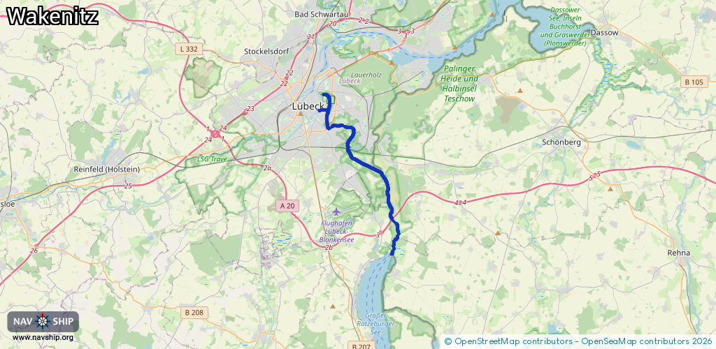
Route:
Please wait, loading route graphic...
Request waterway overview map with symbol legend here (Link).
Information about data associated with this body of water (13 available):
Data by OpenSeaMap (c) OSM contributors, www.openseamap.org
| # | Kind | Coordinates | Name | Information |
|---|---|---|---|---|
| 1 | Marina | 53.87306,10.70615 | 2025-06-27T16:47:50Z | Lübecker Yachtclub [email protected] +49 451 33839 https://www.lyc.de/ |
| 2 | Marina | 53.85276,10.73112 | 2025-09-04T05:16:06Z | Segler-Verein-Wakenitz e.V. http://www.sv-wakenitz.com/ |
| 3 | Marina | 53.84595,10.7302 | 2023-01-14T22:55:13Z | Eichholzer Wassersport-Verein e.V. 1964 http://www.eichholzer-wassersportverein.de/ |
| 4 | Bridge | 53.86309,10.70407 | Unknown | Clearance height: 2012-12-14T15:45:03Z m fixed |
| 5 | Bridge | 53.85367,10.70374 | Unknown | Clearance height: 2012-12-14T15:45:16Z m fixed |
| 6 | Bridge | 53.84134,10.72362 | Unknown | Clearance height: 2012-12-14T15:45:03Z m fixed |
| 7 | Bridge | 53.8004,10.76706 | Unknown | Clearance height: 2016-02-26T13:54:59Z m fixed |
| 8 | Bridge | 53.79667,10.77227 | Unknown | Clearance height: 2013-05-07T10:18:09Z m fixed |
| 9 | Bridge | 53.78264,10.76732 | Unknown | Clearance height: 2012-12-14T15:45:03Z m fixed |
| 10 | Slipway | 53.87435,10.70312 | small_craft_facility | 2025-01-05T20:49:41Z |
| 11 | Slipway | 53.86508,10.70368 | small_craft_facility | 2016-01-06T09:16:19Z |
| 12 | Slipway | 53.86498,10.70369 | small_craft_facility | 2016-01-06T09:16:19Z |
| 13 | Slipway | 53.86233,10.70249 | small_craft_facility | 2012-12-14T15:45:16Z |