Waterway information

Kind:
Lake
Driving areas:
🇨🇭 Switzerland
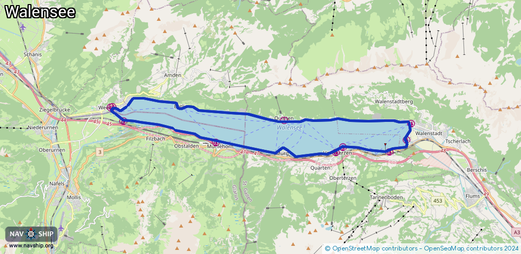
Length:
34.7 km¹
¹River kilometers or bank length recorded in NavShip, including river arms and harbor entrances.
Availability:
Completely recorded
Recent Update: 22.02.2026²
² This date indicates when an adjustment last took place in the course of the body of water
Recorded:
Locks: 0
Harbours / marinas: 10
Bridges: 0
Berths: 0
Slipways: 5
Fuelstations: 0
Route:
Please wait, loading route graphic...
Request waterway overview map with symbol legend here (Link).
Information about data associated with this body of water (15 available):
Data by OpenSeaMap (c) OSM contributors, www.openseamap.org
| # | Kind | Coordinates | Name | Information |
|---|---|---|---|---|
| 1 | Marina | 47.12837,9.10801 | 2021-08-06T15:20:55Z | Hafen Gäsi |
| 2 | Marina | 47.11855,9.16989 | 2021-09-25T15:18:14Z | Bootshafen Mühlehorn |
| 3 | Marina | 47.11396,9.25125 | 2021-08-05T09:58:19Z | |
| 4 | Marina | 47.11639,9.25589 | 2024-02-28T08:43:29Z | |
| 5 | Marina | 47.11419,9.28726 | 2022-03-10T10:32:39Z | |
| 6 | Marina | 47.11976,9.29874 | 2022-03-17T15:00:27Z | |
| 7 | Marina | 47.12729,9.30193 | 2023-05-24T23:13:31Z | Hafen Walenstadt |
| 8 | Marina | 47.12879,9.21643 | 2016-09-12T19:21:23Z | Quinten |
| 9 | Marina | 47.13501,9.10049 | 2025-02-25T02:53:49Z | Weesen |
| 10 | Marina | 47.13467,9.09913 | 2023-05-24T23:45:39Z | Weesen |
| 11 | Slipway | 47.11354,9.25018 | small_craft_facility | 2022-04-18T10:03:33Z |
| 12 | Slipway | 47.11453,9.25371 | small_craft_facility | 2022-03-17T14:55:36Z |
| 13 | Slipway | 47.11884,9.29901 | Unknown | 2022-03-17T14:28:25Z |
| 14 | Slipway | 47.11886,9.29906 | small_craft_facility | 2022-03-17T14:55:36Z |
| 15 | Slipway | 47.12863,9.22712 | small_craft_facility | 2016-09-12T19:21:24Z |