Waterway information

Kind:
Inland
Driving areas:
🇬🇧 United Kingdom
Length:
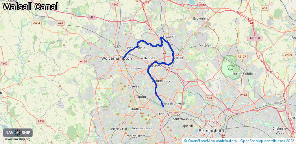
26.8 km¹
¹River kilometers or bank length recorded in NavShip, including river arms and harbor entrances.
Availability:
Completely recorded
Recent Update: 01.04.2025²
² This date indicates when an adjustment last took place in the course of the body of water
Recorded:
Locks: 16
Harbours / marinas: 1
Bridges: 0
Berths: 0
Slipways: 0
Fuelstations: 0
Route:
Please wait, loading route graphic...
Request waterway overview map with symbol legend here (Link).
Information about data associated with this body of water (17 available):
Data by OpenSeaMap (c) OSM contributors, www.openseamap.org
| # | Kind | Coordinates | Name | Information |
|---|---|---|---|---|
| 1 | Marina | 52.53263,-2.0336 | 2024-05-31T01:28:36Z | Ryder's Green Interchange Basin |
| 2 | Lock | 52.52331,-2.0228 | Unknown | |
| 3 | Lock | 52.52423,-2.0239 | Unknown | |
| 4 | Lock | 52.52508,-2.02495 | Unknown | |
| 5 | Lock | 52.52601,-2.0261 | Unknown | |
| 6 | Lock | 52.52778,-2.02825 | Unknown | |
| 7 | Lock | 52.52688,-2.02716 | Unknown | |
| 8 | Lock | 52.58572,-1.99295 | Unknown | |
| 9 | Lock | 52.58754,-1.99357 | Unknown | |
| 10 | Lock | 52.58834,-1.99384 | Unknown | |
| 11 | Lock | 52.58929,-1.99405 | Unknown | |
| 12 | Lock | 52.59025,-1.99389 | Unknown | |
| 13 | Lock | 52.59112,-1.99376 | Unknown | |
| 14 | Lock | 52.59237,-1.99359 | Unknown | |
| 15 | Lock | 52.59747,-1.99702 | Unknown | |
| 16 | Lock | 52.59722,-2.09208 | Unknown | |
| 17 | Lock | 52.58548,-2.11222 | Unknown |