Waterway information

Kind:
Inland
Driving areas:
🇩🇪 Germany
Length:
1.1 km¹
¹River kilometers or bank length recorded in NavShip, including river arms and harbor entrances.
Availability:
Completely recorded
Recent Update: 22.06.2023²
² This date indicates when an adjustment last took place in the course of the body of water
Recorded:
Locks: 0
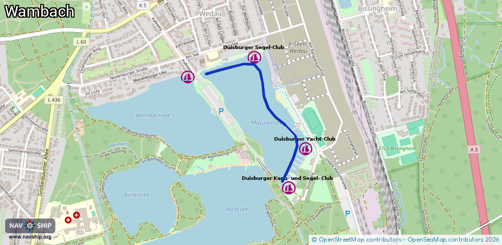
Harbours / marinas: 4
Bridges: 0
Berths: 0
Slipways: 0
Fuelstations: 0
Route:
Please wait, loading route graphic...
Request waterway overview map with symbol legend here (Link).
Information about data associated with this body of water (4 available):
Data by OpenSeaMap (c) OSM contributors, www.openseamap.org
| # | Kind | Coordinates | Name | Information |
|---|---|---|---|---|
| 1 | Marina | 51.38255,6.80397 | 2020-12-06T16:18:46Z | Duisburger Kanu- und Segel- Club [email protected] +49 203 724492 https://www.dksc.de/ http://www.dksc.de/wordpress/wp-content/uploads/2011/09/Opti-B-2011-0349-300x250.jpg |
| 2 | Marina | 51.38469,6.80545 | 2018-08-09T18:28:38Z | Duisburger Yacht-Club +49 203 726118 https://www.duyc.de |
| 3 | Marina | 51.38969,6.80096 | 2019-03-28T12:10:46Z | Duisburger Segel-Club +49 172 2970306 https://duisburgersegelclub.de/ |
| 4 | Marina | 51.38862,6.79514 | 2022-06-29T11:22:43Z | Kanusport-Verein DU-Wedau https://www.ksv-duisburg-wedau.de/ |