Waterway information

Kind:
Inland
Driving areas:
🌊 Atlantic Ocean🇺🇸 United States of America
Length:
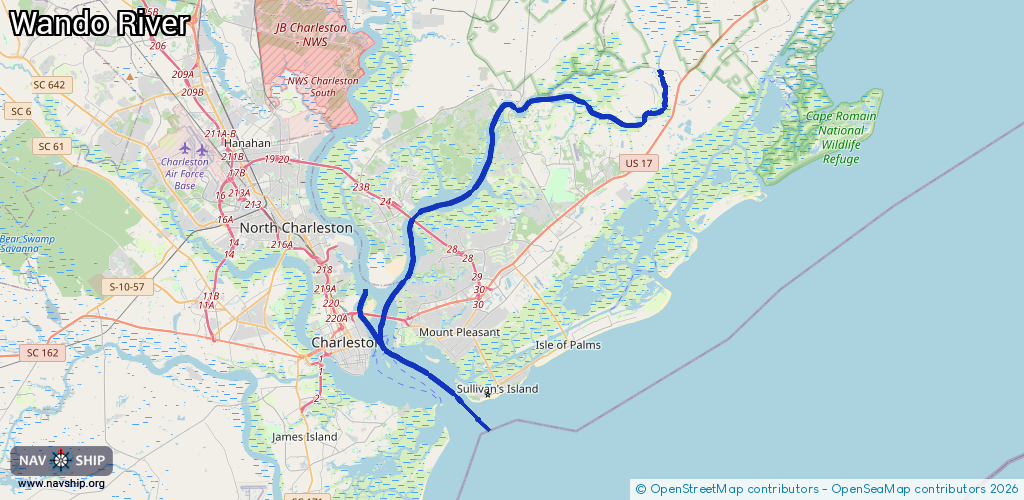
46.5 km¹
¹River kilometers or bank length recorded in NavShip, including river arms and harbor entrances.
Availability:
Completely recorded
Recent Update: 15.05.2025²
² This date indicates when an adjustment last took place in the course of the body of water
Recorded:
Locks: 0
Harbours / marinas: 3
Bridges: 2
Berths: 1
Slipways: 0
Fuelstations: 0
Route:
Please wait, loading route graphic...
Request waterway overview map with symbol legend here (Link).
Information about data associated with this body of water (6 available):
Data by OpenSeaMap (c) OSM contributors, www.openseamap.org
| # | Kind | Coordinates | Name | Information |
|---|---|---|---|---|
| 1 | Marina | 32.80281,-79.93262 | 2025-05-23T02:01:35Z | Seabreeze Marina +1-843-853-0932 |
| 2 | Marina | 32.78898,-79.92421 | 2025-10-05T02:54:08Z | Charleston Maritime Center +1- 843-853-3625 https://www.charleston-sc.gov/155/Maritime-Center |
| 3 | Marina | 32.78684,-79.90996 | 2021-11-03T04:37:52Z | Charleston Harbor Resort & Marina |
| 4 | Bridge | 32.80289,-79.91529 | 304.8 | Clearance height: 2021-04-07T16:59:26Z m Maximum passage width: 56.6 m Movable bridge (e.g. lifting bridge or drawbridge) |
| 5 | Bridge | 32.80302,-79.91528 | 304.8 | Clearance height: 2021-04-07T16:59:26Z m Maximum passage width: 56.6 m Movable bridge (e.g. lifting bridge or drawbridge) |
| 6 | Berth | 32.78349,-79.92013 | 2021-04-07T18:26:49Z | Commercial Anchorage D 24_hour |