Waterway information

Kind:
Inland
Driving areas:
🇳🇱 Netherlands🌊 North Sea
Length:
8.7 km¹
¹River kilometers or bank length recorded in NavShip, including river arms and harbor entrances.
Availability:
Completely recorded
Recent Update: 04.03.2025²
² This date indicates when an adjustment last took place in the course of the body of water
Recorded:
Locks: 0
Harbours / marinas: 7
Bridges: 6
Berths: 0
Slipways: 0
Fuelstations: 0
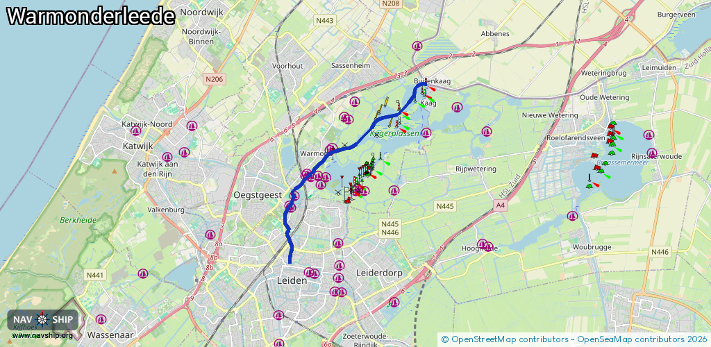
Route:
Please wait, loading route graphic...
Request waterway overview map with symbol legend here (Link).
Information about data associated with this body of water (13 available):
Data by OpenSeaMap (c) OSM contributors, www.openseamap.org
| # | Kind | Coordinates | Name | Information |
|---|---|---|---|---|
| 1 | Marina | 52.18137,4.49021 | 2021-12-26T15:20:43Z | Jachthaven Poelgeest |
| 2 | Marina | 52.18212,4.48961 | 2021-12-26T15:11:52Z | Jachthaven Welgelegen https://jachthavenwelgelegen.nl/ |
| 3 | Marina | 52.18488,4.49203 | 2020-10-17T23:32:36Z | Jachthaven Zwanengat |
| 4 | Marina | 52.19121,4.49759 | 2020-10-21T21:30:16Z | Watersportvereniging De Kaag https://www.kwvdekaag.nl |
| 5 | Marina | 52.1916,4.49842 | 2023-05-30T22:11:08Z | Jachthaven Lockhorst https://www.lockhorst.nl |
| 6 | Marina | 52.19068,4.50059 | 2020-10-17T21:44:16Z | Watersportvereniging De Kaag |
| 7 | Marina | 52.19879,4.50955 | 2022-06-02T22:24:37Z | Cieco https://cieco.nl/ |
| 8 | Bridge | 52.16473,4.48954 | Unknown | Clearance height: 2020-10-29T10:58:07Z m Movable bridge (e.g. lifting bridge or drawbridge) fixed |
| 9 | Bridge | 52.18994,4.49671 | 10.4 | Clearance height: 2020-07-06T10:32:18Z m Maximum passage width: 2.7 m Movable bridge (e.g. lifting bridge or drawbridge) fixed |
| 10 | Bridge | 52.18973,4.49646 | 10.4 | Clearance height: 2020-07-06T10:32:18Z m Maximum passage width: 2.7 m Movable bridge (e.g. lifting bridge or drawbridge) fixed |
| 11 | Bridge | 52.18977,4.49676 | 10.4 | Clearance height: 2020-07-06T10:32:18Z m Maximum passage width: 2.7 m Movable bridge (e.g. lifting bridge or drawbridge) fixed |
| 12 | Bridge | 52.18955,4.49651 | 10.4 | Clearance height: 2020-07-06T10:32:18Z m Maximum passage width: 2.7 m Movable bridge (e.g. lifting bridge or drawbridge) fixed |
| 13 | Bridge | 52.19417,4.5033 | 15 | Clearance height: 2020-07-06T10:32:18Z m Maximum passage width: 2.7 m Movable bridge (e.g. lifting bridge or drawbridge) opening |