Waterway information

Kind:
Inland
Driving areas:
🌊 North Sea🇬🇧 United Kingdom
Length:
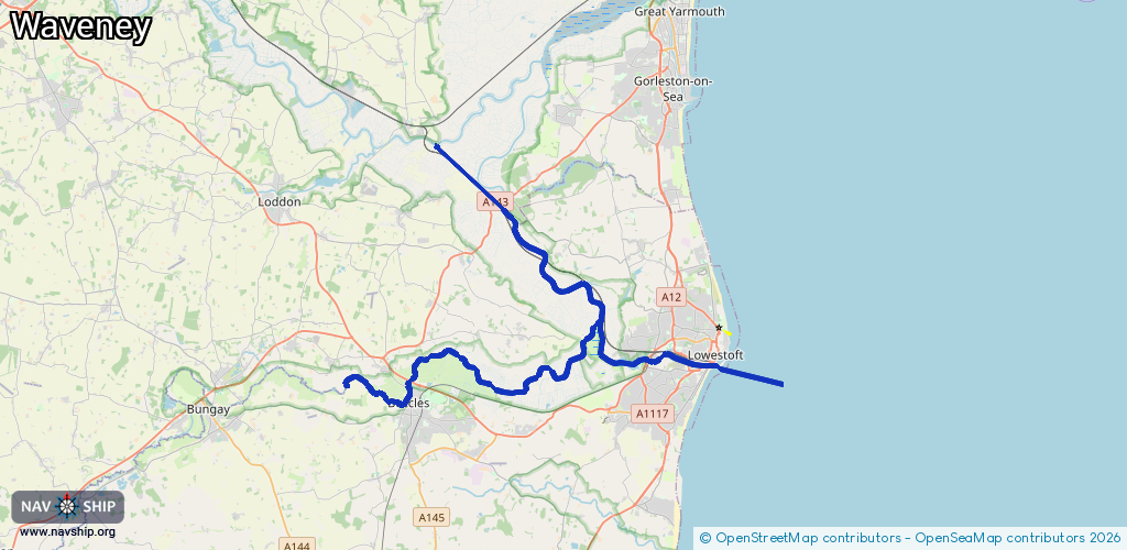
38.3 km¹
¹River kilometers or bank length recorded in NavShip, including river arms and harbor entrances.
Availability:
Completely recorded
Recent Update: 15.04.2025²
² This date indicates when an adjustment last took place in the course of the body of water
Recorded:
Locks: 1
Harbours / marinas: 6
Bridges: 0
Berths: 0
Slipways: 1
Fuelstations: 1
Route:
Please wait, loading route graphic...
Request waterway overview map with symbol legend here (Link).
Information about data associated with this body of water (9 available):
Data by OpenSeaMap (c) OSM contributors, www.openseamap.org
| # | Kind | Coordinates | Name | Information |
|---|---|---|---|---|
| 1 | Marina | 52.47212,1.75069 | 2026-02-03T15:16:20Z | Royal Norfolk & Suffolk Yacht Club https://www.rnsyc.net/wordpress/ |
| 2 | Marina | 52.47507,1.71656 | 2022-11-11T15:42:41Z | Lowestoft Cruising Club |
| 3 | Marina | 52.4572,1.55964 | 2024-06-27T16:18:20Z | Galleon Storage & Mooring Ltd [email protected] +44 1502 714154 https://www.galleon-storage-and-mooring.co.uk/ |
| 4 | Marina | 52.48232,1.67052 | 2021-08-14T22:11:45Z | |
| 5 | Marina | 52.48289,1.67129 | 2024-12-18T20:14:05Z | |
| 6 | Marina | 52.48326,1.67217 | 2021-08-14T22:11:45Z | |
| 7 | Slipway | 52.47227,1.75034 | small_craft_facility | 2021-01-13T11:57:11Z |
| 8 | Fuel station | 52.47243,1.75044 | 2015-05-08T01:28:06Z | |
| 9 | Lock | 52.47488,1.71078 | Unknown |