Waterway information

Kind:
Inland
Driving areas:
🇬🇧 United Kingdom
Length:
35.7 km¹
¹River kilometers or bank length recorded in NavShip, including river arms and harbor entrances.
Availability:
Completely recorded
Recent Update: 06.08.2020²
² This date indicates when an adjustment last took place in the course of the body of water
Recorded:
Locks: 16
Harbours / marinas: 2
Bridges: 0
Berths: 0
Slipways: 0
Fuelstations: 0
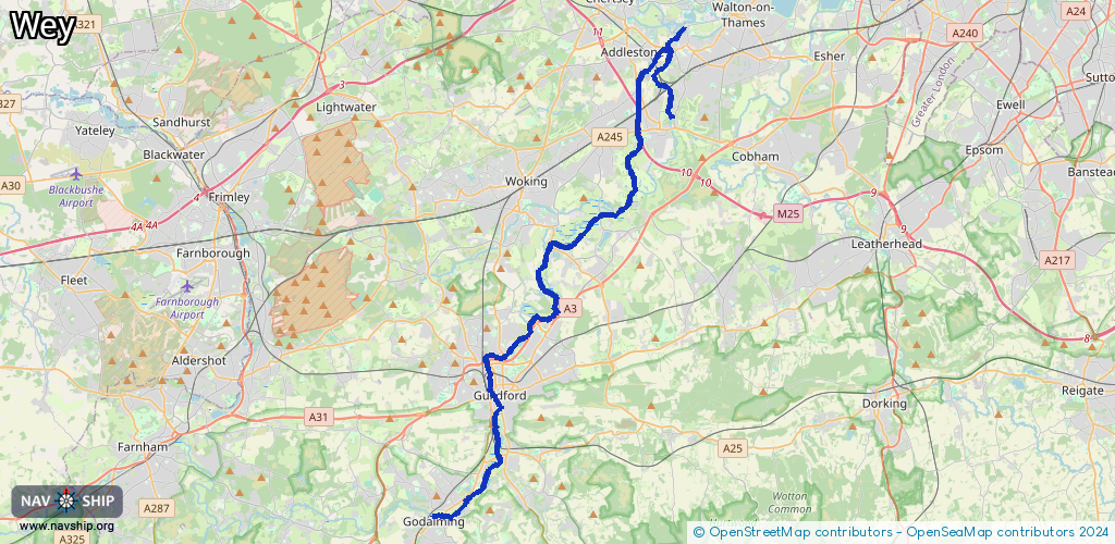
Route:
Please wait, loading route graphic...
Request waterway overview map with symbol legend here (Link).
Information about data associated with this body of water (18 available):
Data by OpenSeaMap (c) OSM contributors, www.openseamap.org
| # | Kind | Coordinates | Name | Information |
|---|---|---|---|---|
| 1 | Marina | 51.29435,-0.52752 | 2025-07-17T18:18:54Z | Cartbridge Basin |
| 2 | Marina | 51.32409,-0.49221 | 2025-04-29T08:36:26Z | Pyrford Marina |
| 3 | Lock | 51.19108,-0.59799 | Unknown | |
| 4 | Lock | 51.20474,-0.58156 | Unknown | |
| 5 | Lock | 51.21989,-0.57544 | St Catherine | St Catherine |
| 6 | Lock | 51.23295,-0.57497 | Millmead Lock | +447786703831 |
| 7 | Lock | 51.25485,-0.56555 | Stoke Lock | |
| 8 | Lock | 51.26664,-0.55108 | Bowers Lock | |
| 9 | Lock | 51.28396,-0.54931 | Triggs Lock | |
| 10 | Lock | 51.29132,-0.54428 | Unknown | |
| 11 | Lock | 51.3012,-0.51812 | Papercourt Lock | |
| 12 | Lock | 51.3071,-0.50575 | The National Trust - Newark Lock | |
| 13 | Lock | 51.30976,-0.49477 | Ripley Weir | |
| 14 | Lock | 51.32227,-0.48955 | Pyrford Lock | |
| 15 | Lock | 51.35707,-0.48619 | New Haw Lock | |
| 16 | Lock | 51.36628,-0.47711 | Coxes Lock | |
| 17 | Lock | 51.37162,-0.46686 | Town Lock | |
| 18 | Lock | 51.37869,-0.46041 | Thames Lock |