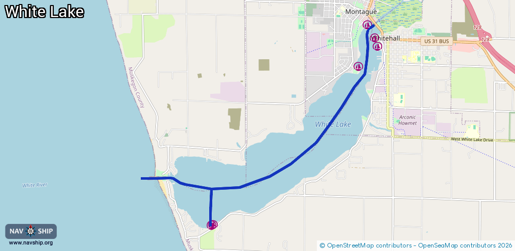
Waterway information

Kind:
Inland
Driving areas:
🇺🇸 United States of America
Length:
10 km¹
¹River kilometers or bank length recorded in NavShip, including river arms and harbor entrances.
Availability:
Completely recorded
Recent Update: 24.06.2025²
² This date indicates when an adjustment last took place in the course of the body of water
Recorded:
Locks: 0
Harbours / marinas: 6
Bridges: 0
Berths: 0
Slipways: 0
Fuelstations: 1
Route:
Please wait, loading route graphic...
Request waterway overview map with symbol legend here (Link).
Information about data associated with this body of water (7 available):
Data by OpenSeaMap (c) OSM contributors, www.openseamap.org
| # | Kind | Coordinates | Name | Information |
|---|---|---|---|---|
| 1 | Marina | 43.40306,-86.35807 | 2022-06-18T14:00:49Z | Maple Beach Yacht Club +1 231-292-6332 https://www.facebook.com/pages/category/Marina/Maple-Beach-Marina-371735620062468/ |
| 2 | Marina | 43.40783,-86.35123 | 2022-04-25T21:52:40Z | Lucky Dog Landing |
| 3 | Marina | 43.41019,-86.35256 | 2026-01-10T23:07:53Z | White Lake Municipal Marina |
| 4 | Marina | 43.41355,-86.35482 | 2022-04-25T21:52:40Z | Ellenwood Marina |
| 5 | Marina | 43.36347,-86.40808 | 2022-07-09T01:22:18Z | South Shore Marine +1 231 893 3935 http://www.southshoremarine.net/ |
| 6 | Marina | 43.36368,-86.40755 | 2022-07-09T01:22:18Z | White Lake Yacht Club +1 231 894 4516 https://wlyc.org/ |
| 7 | Fuel station | 43.41013,-86.35303 | 2023-08-28T12:14:02Z |