Waterway information

Kind:
Inland
Driving areas:
🇳🇱 Netherlands
Length:
15.4 km¹
¹River kilometers or bank length recorded in NavShip, including river arms and harbor entrances.
Availability:
Completely recorded
Recent Update: 24.07.2023²
² This date indicates when an adjustment last took place in the course of the body of water
Recorded:
Locks: 2
Harbours / marinas: 1
Bridges: 9
Berths: 0
Slipways: 0
Fuelstations: 0
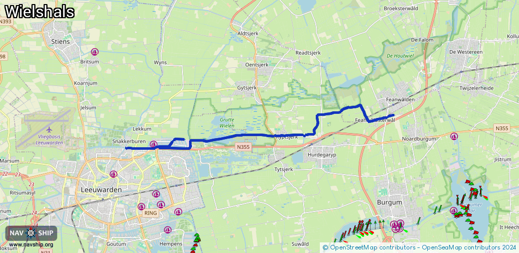
Route:
Please wait, loading route graphic...
Request waterway overview map with symbol legend here (Link).
Information about data associated with this body of water (10 available):
Data by OpenSeaMap (c) OSM contributors, www.openseamap.org
| # | Kind | Coordinates | Name | Information |
|---|---|---|---|---|
| 1 | Marina | 53.21893,5.82696 | 2022-05-08T18:30:02Z | Blitsaerd Haven https://www.blitsaerd.nl/ligplaatsen-vaarwater |
| 2 | Bridge | 53.22972,5.97138 | Unknown | Clearance height: 2025-11-23T19:20:19Z m fixed |
| 3 | Bridge | 53.22252,5.90862 | Unknown | Clearance height: 2022-01-13T22:24:56Z m |
| 4 | Bridge | 53.21736,5.84875 | Unknown | Clearance height: 2023-05-22T18:44:06Z m Movable bridge (e.g. lifting bridge or drawbridge) fixed |
| 5 | Bridge | 53.218,5.82895 | 10.4 | Clearance height: 2022-01-14T11:15:00Z m Maximum passage width: 3 m fixed |
| 6 | Bridge | 53.21736,5.82674 | 7.73 | Clearance height: 2022-01-14T11:15:00Z m Maximum passage width: 3 m fixed |
| 7 | Bridge | 53.21743,5.81471 | 5 | Clearance height: 2019-04-30T18:22:17Z m Maximum passage width: 2.95 m fixed |
| 8 | Bridge | 53.21743,5.80905 | 4.90 | Clearance height: 2025-04-22T18:22:57Z m Maximum passage width: 3.01 m Movable bridge (e.g. lifting bridge or drawbridge) fixed |
| 9 | Bridge | 53.21814,5.84162 | Unknown | Clearance height: 2023-05-22T18:44:06Z m fixed |
| 10 | Bridge | 53.2181,5.83334 | Unknown | Clearance height: 2023-05-22T18:44:06Z m fixed |
| 10 | Bridge | 53.2181,5.83334 | Unknown | Clearance height: 2023-05-22T18:44:06Z m fixed |
| 10 | Bridge | 53.2181,5.83334 | Unknown | Clearance height: 2023-05-22T18:44:06Z m fixed |