Waterway information

Kind:
Inland
Driving areas:
🇳🇱 Netherlands
Length:
7 km¹
¹River kilometers or bank length recorded in NavShip, including river arms and harbor entrances.
Availability:
Completely recorded
Recent Update: 22.05.2023²
² This date indicates when an adjustment last took place in the course of the body of water
Recorded:
Locks: 0
Harbours / marinas: 0
Bridges: 0
Berths: 19
Slipways: 0
Fuelstations: 0
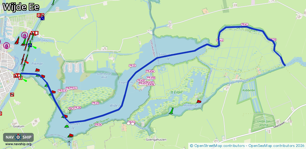
Route:
Please wait, loading route graphic...
Request waterway overview map with symbol legend here (Link).
Information about data associated with this body of water (19 available):
Data by OpenSeaMap (c) OSM contributors, www.openseamap.org
| # | Kind | Coordinates | Name | Information |
|---|---|---|---|---|
| 1 | Berth | 53.09055,5.86035 | 2023-11-21T00:33:16Z | PR51F |
| 2 | Berth | 53.0906,5.86136 | 2023-11-21T00:33:16Z | PR51I |
| 3 | Berth | 53.09014,5.85815 | 2023-11-21T00:33:16Z | PR51H |
| 4 | Berth | 53.08706,5.86096 | 2023-11-21T00:33:16Z | PR27 |
| 5 | Berth | 53.08724,5.86227 | 2023-11-21T00:33:16Z | PR28 |
| 6 | Berth | 53.0842,5.86855 | 2023-11-21T00:33:16Z | PR54 |
| 7 | Berth | 53.08799,5.86768 | 2023-11-21T00:33:16Z | PR29 |
| 8 | Berth | 53.09446,5.87833 | 2023-11-21T00:33:14Z | PR31 |
| 9 | Berth | 53.09349,5.8834 | 2024-02-05T17:02:43Z | PR45A |
| 10 | Berth | 53.09235,5.88361 | 2024-02-05T17:02:43Z | PR45B |
| 11 | Berth | 53.09125,5.88349 | 2023-11-21T00:33:14Z | PR45E |
| 12 | Berth | 53.09155,5.88322 | 2023-11-21T00:33:14Z | PR45D |
| 13 | Berth | 53.09143,5.88139 | 2023-11-21T00:33:14Z | PR45G |
| 14 | Berth | 53.09189,5.88085 | 2023-11-21T00:33:14Z | PR45F |
| 15 | Berth | 53.09892,5.90344 | 2023-11-21T00:33:10Z | PR43 |
| 16 | Berth | 53.10162,5.91053 | 2023-11-21T00:33:14Z | PR41 |
| 17 | Berth | 53.10929,5.91411 | 2024-04-29T17:14:38Z | PR16B |
| 18 | Berth | 53.10866,5.921 | 2024-05-04T14:45:28Z | PR15 |
| 19 | Berth | 53.09897,5.91857 | 2023-11-21T00:33:14Z | PR39 |