Waterway information

Kind:
Inland
Driving areas:
🇺🇸 United States of America
Length:
164.7 km¹
¹River kilometers or bank length recorded in NavShip, including river arms and harbor entrances.
Availability:
Completely recorded
Recent Update: 10.04.2025²
² This date indicates when an adjustment last took place in the course of the body of water
Recorded:
Locks: 4
Harbours / marinas: 7
Bridges: 1
Berths: 11
Slipways: 0
Fuelstations: 0
Route:
Please wait, loading route graphic...
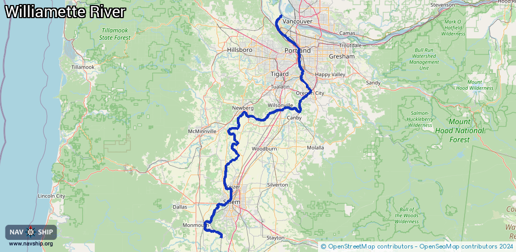
Request waterway overview map with symbol legend here (Link).
Information about data associated with this body of water (19 available):
Data by OpenSeaMap (c) OSM contributors, www.openseamap.org
| # | Kind | Coordinates | Name | Information |
|---|
| 1 | Marina | 45.29177,-122.77524 | 2021-08-14T19:35:20Z | Boones Ferry Marina |
| 2 | Marina | 45.46044,-122.66082 | 2026-02-11T01:53:24Z | Waverly Marina Association
Th-Sa 10:00-18:00, May 01-Oct 31 Th-Su 10:00-18:00
+1-503-231-3985
https://www.waverlymarina.org/ |
| 3 | Marina | 45.47463,-122.66257 | 2026-02-02T04:03:14Z | Oregon Yacht Club
https://oregonyachtclub.com/ |
| 4 | Marina | 45.47853,-122.6699 | 2023-10-28T17:00:50Z | Willamette Sailing Club
https://willamettesailingclub.com/ |
| 5 | Marina | 45.47989,-122.67058 | 2021-08-22T01:51:51Z | Johns Landing Boating Club |
| 6 | Marina | 45.4845,-122.67174 | 2021-08-22T01:51:51Z | Landing Boat Club |
| 7 | Marina | 45.51047,-122.67286 | 2021-07-22T21:30:10Z | River Place Marina |
| 8 | Bridge | 45.35901,-122.60963 | 55.1688 | Clearance height: 2025-10-04T23:08:04Z m
Maximum passage width: 22.5552 m
Movable bridge (e.g. lifting bridge or drawbridge)
fixed |
| 9 | Berth | 45.55019,-122.70251 | 2024-06-20T04:48:50Z | Dredge Essayons
https://www.nap.usace.army.mil/Missions/Factsheets/Fact-Sheet-Article-View/Article/490716/usace-dredge-essayons/ |
| 10 | Berth | 45.5499,-122.70379 | 2024-06-20T04:48:50Z | Dredge Yaquina
https://www.nwp.usace.army.mil/Media/Images/igphoto/2002979128/ |
| 11 | Berth | 45.57063,-122.72294 | 2023-11-19T02:46:48Z | USCGC Bluebell
Commissinged in 1945, BLUEBELL services over 420 navigational buoys along 500 miles of river, on the Columbia River to Kennewick, WA, the Willamette River to Portland, OR and the Snake River to Lewiston, ID.
https://www.dvidshub.net/image/6310072/coast-guard-cutter-bluebell-underway-columbia-river |
| 12 | Berth | 45.59391,-122.77161 | 2015-09-02T18:58:53Z | Berth 416 |
| 13 | Berth | 45.59642,-122.77357 | 2015-09-02T18:58:52Z | Berth 415 |
| 14 | Berth | 45.59746,-122.77442 | 2015-09-02T18:58:52Z | Berth 414 |
| 15 | Berth | 45.60466,-122.77433 | 2015-09-02T18:58:52Z | Berth 405 |
| 16 | Berth | 45.6036,-122.77432 | 2015-09-02T18:58:52Z | Berth 408 |
| 17 | Berth | 45.60124,-122.77404 | 2015-09-02T18:58:52Z | Berth 411 |
| 18 | Berth | 45.6015,-122.77633 | 2017-09-30T17:37:25Z | Berth 410 |
| 19 | Berth | 45.60553,-122.78016 | 2015-09-02T18:58:52Z | Berth 401 |
| 19 | Berth | 45.60553,-122.78016 | 2015-09-02T18:58:52Z | Berth 401 |
| 19 | Berth | 45.60553,-122.78016 | 2015-09-02T18:58:52Z | Berth 401 |
| 19 | Berth | 45.60553,-122.78016 | 2015-09-02T18:58:52Z | Berth 401 |
| 19 | Berth | 45.60553,-122.78016 | 2015-09-02T18:58:52Z | Berth 401 |