Waterway information

Kind:
Inland
Driving areas:
🇩🇪 Germany
Length:
5 km¹
¹River kilometers or bank length recorded in NavShip, including river arms and harbor entrances.
Availability:
Completely recorded
Recent Update: 09.07.2024²
² This date indicates when an adjustment last took place in the course of the body of water
Recorded:
Locks: 0
Harbours / marinas: 4
Bridges: 2
Berths: 0
Slipways: 0
Fuelstations: 0
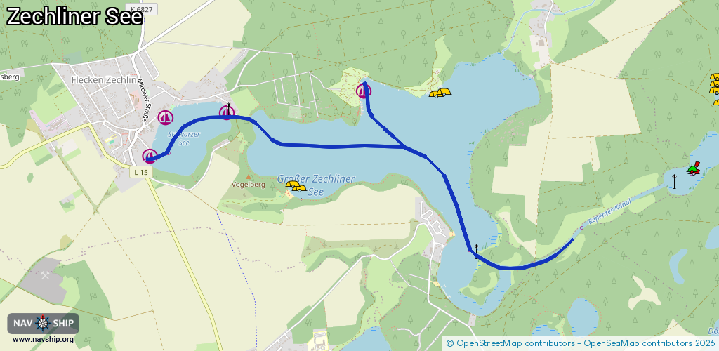
Route:
Please wait, loading route graphic...
Request waterway overview map with symbol legend here (Link).
Information about data associated with this body of water (6 available):
Data by OpenSeaMap (c) OSM contributors, www.openseamap.org
| # | Kind | Coordinates | Name | Information |
|---|---|---|---|---|
| 1 | Marina | 53.16092,12.79589 | 2012-12-12T12:22:32Z | Anleger D82 - Campingplätze am Grossen Zechliner See +49 33923 71017 http://www.camping-fleckenzechlin.de/index.html |
| 2 | Marina | 53.15614,12.76978 | 2025-06-24T17:59:43Z | Fischerhütte +49 33923 70530 |
| 3 | Marina | 53.15897,12.77166 | 2023-11-07T16:28:42Z | Bootsverleih Fa. Maranke [email protected] +49 33923 70155 https://www.boote-rheinsberg-zechlin.de/ |
| 4 | Marina | 53.15934,12.77915 | 2025-06-24T17:59:43Z | Cafe zur Brücke [email protected] +49 33923 70471 http://www.cafezurbruecke.de/ |
| 5 | Bridge | 53.15904,12.78029 | Unknown | Clearance height: 2022-07-26T15:17:00Z m Maximum passage width: 4.45 m Movable bridge (e.g. lifting bridge or drawbridge) fixed |
| 6 | Bridge | 53.14831,12.81685 | 5.4 | Clearance height: 2022-07-26T15:17:00Z m Maximum passage width: 3.6 m Movable bridge (e.g. lifting bridge or drawbridge) fixed |